
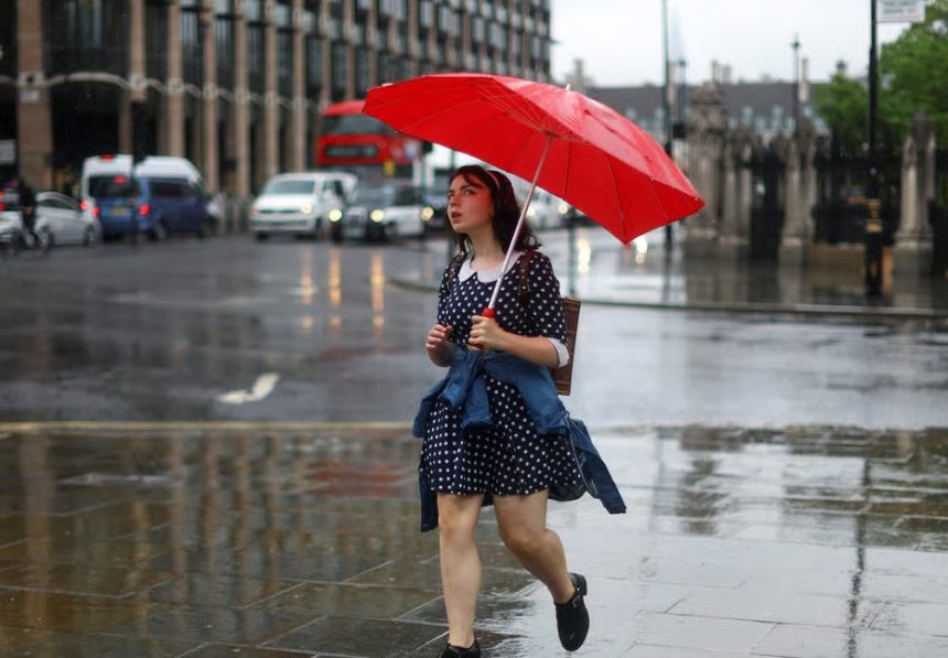
The United Kingdom’s brief brush with summer has been unceremoniously cut short as a volatile Atlantic UK weather system moves in, threatening to disrupt one of the biggest weekends in the British sporting calendar.
Following a record-breaking early April heatwave that saw temperatures hit 26°C in London and 24.8°C in Wales, the Met Office has confirmed a “sharp transition” to unsettled, windier, and significantly colder conditions for Friday 10 April and Saturday 11 April.
With over 150,000 racing fans descending on Aintree for the Grand National, all eyes are on the skies.
Forecasters warn that a “squally” band of rain and coastal gales will replace the sunshine, with some areas of the UK facing wind gusts of up to 60–70mph and a temperature drop of more than 10°C.
Why is the UK Weather Changing So Drastically?
The current meteorological shift is driven by a deepening area of low pressure in the North Atlantic. For the past few days, a southerly airflow dragged warm continental air across the English Channel, causing the “mini-heatwave.”
A chilly but bright start on Friday morning 🌥️
Turning wetter and windier in the far west 🌧️
A cooler day ahead for all 🌡️ pic.twitter.com/E84R924IwR
— Met Office (@metoffice) April 9, 2026
However, the jet stream has now shifted south, opening the gates for a cold front to sweep across the British Isles.
This transition began in the northwest on Thursday and is now pushing southeast. The warm air is being “shunted” into the North Sea, allowing polar maritime air to rush in.
As daytime temperatures fall, overnight values will drop too 🌡️
Expect a much chillier night for all, with clear skies and easing winds, allowing a patchy frost to develop pic.twitter.com/ao5Vy3U6DN
— Met Office (@metoffice) April 9, 2026
This not only brings rain but also increases atmospheric instability, leading to the risk of thundery showers and even hail in western districts.
Which Areas Face the Worst of the Wind and Rain?
The impact of this system is widespread but varies significantly by region:
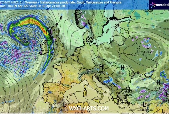
- North West England (Aintree/Liverpool): Saturday’s Grand National faces a “wet and windy” outlook. WXCharts and Met Office maps indicate widespread rain arriving during the peak of the racing schedule, with gusts potentially reaching 50mph in the Mersey area.
- Western Scotland & The Hebrides: This region remains the most vulnerable. Severe coastal gales are expected tonight, with gusts of 70mph possible in exposed spots like Stornoway.
- Wales: After being the UK’s “hotspot” earlier this week, Wales will see “blue maps” return as rain turns heavy and thundery across Anglesey and the Pembrokeshire coast.
- Northern Ireland: Residents in Belfast and Derry should expect squally bursts of rain through Friday afternoon, followed by a “chilly” night with local rural frosts.
How Will This Affect the Grand National at Aintree?
For the thousands attending the Grand National Festival, the weather is a primary concern. Unlike the dry, firm ground seen during Thursday’s opening, Saturday is projected to be “unfavourable.”
- The Ground: Heavy rain on Friday night and Saturday morning could alter the going at the Aintree course, shifting it from ‘Good’ to ‘Soft’ in places, which significantly impacts betting odds and horse performance.
- Spectator Safety: High winds can lead to the temporary closure of certain temporary structures or hospitality marquees. Organizers are monitoring the situation closely but currently expect the event to proceed.
What Do the Official Sources Say?
The Met Office has not yet issued a formal name for this specific weekend’s system (which would follow Storm Dave), but “Yellow” warnings for rain and wind remain under constant review.
“The transition away from the recent warmth is now complete. Friday night will be particularly wet and windy with gales on western, northern, and eastern coasts. We are seeing a return to typical, albeit unsettled, April weather,” says a Met Office spokesperson. “
National Rail and Transport for Ireland have already issued advisories. Passengers on the West Coast Main Line and ferry travelers across the Irish Sea are warned of potential delays due to “wave overtopping” and high winds.
Is There a Risk of Snow or Frost This Weekend?
While the 26°C heat is a distant memory, the cold air behind the front is sufficient to bring a wintry flavor to the hills.
- Hill Snow: In Northern Scotland, showers may turn wintry over high ground (above 300m) tonight.
- Rural Frost: As the rain clears eastward on Friday night, clear skies over the Midlands and Northern England could see temperatures drop to 1°C or 2°C, leading to a “crisp but frosty” start for early Saturday morning.
Impact on UK Travel and Infrastructure
- Aviation: Following 1,600 flight delays across Europe on April 9 due to air-traffic-control and weather issues, Heathrow and Gatwick remain on high alert. Wind shears can frequently cause “go-around” landings during such gale-force conditions.
- Roads: The RAC has advised drivers to be wary of “buffeting” when overtaking high-sided vehicles on the M6 and M74.
- Coastal Flooding: The UK Environment Agency is monitoring spring tides. Strong onshore winds combined with high waves may lead to localized flooding in low-lying western coastal areas.
What Happens Next?
Looking ahead to Sunday, 12 April, the weather remains “changeable.” While the most intense gales will have passed, a “mobile Atlantic flow” continues. This means a mix of sunny spells and blustery showers will dominate the day.
Temperatures will struggle to reach 11°C or 12°C, which is the seasonal average for mid-April. Monday 13 April currently looks to be the driest day of the next period, as a brief ridge of high pressure moves in, offering a small window of respite before the next Atlantic front arrives on Tuesday.