The United Kingdom is facing a sharp reminder that spring in the British Isles is often a fleeting concept.
As we move through the final weekend of March 2026, a potent Arctic maritime airmass has displaced the milder conditions of previous weeks, plunging the country into a cold snap characterised by wintry showers, widespread frost, and biting winds.
While many had hoped for settled spring sunshine, the Met Office has confirmed that a “poker-chip” shower pattern, bringing a volatile mix of hail, sleet, and snow, is now the dominant theme for Saturday 28 and Sunday 29 March.
Why is the UK Facing a Sudden Return to Winter?
The current weather shift is driven by a deep area of low pressure currently situated over the Norwegian Sea. This system is acting as a “conveyor belt,” dragging cold, polar air directly from the Arctic across the North Sea.
Meteorologically, this is often referred to as “Lambing Snow”, a traditional British term for late-season snowfalls that coincide with the spring lambing season.
A chilly start to Saturday morning with pockets of frost in places ❄️
A band of organised showers brings persistent spells of rain and hill snow for a time in Northern Ireland and southern Scotland 🌦️
Otherwise sunny spells and showers but feeling cold in brisk winds 🥶 pic.twitter.com/POeLPPu8Dg
— Met Office (@metoffice) March 27, 2026
Unlike the settled snow of January, this weekend’s event is characterised by its “squally” nature.
On Saturday, 28 March, the UK is experiencing high atmospheric instability, meaning clear blue skies can turn into dark, thundery hailstorms within minutes.
Which UK Regions are Most at Risk of Snow and Ice?
The impact of this cold front is not uniform across the four nations. Here is a breakdown of the most affected locations:
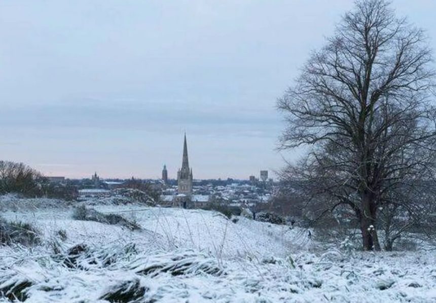
- Scotland & Northern Highlands: Significant snow accumulations are occurring on ground above 300 metres. Areas such as the Cairngorms National Park, Inverness-shire, and the Grampians are seeing “white-out” conditions during heavy showers.
- Northern England & The Pennines: Commuter routes like the A66 and M62 have seen a dusting of sleet and snow. Cities such as Leeds, Sheffield, and Manchester are largely seeing rain and hail, though higher suburbs are reporting slushy accumulations.
- Wales: The peaks of Eryri (Snowdonia) and the Brecon Beacons are experiencing wintry flurries. In the valleys, heavy rain is being accompanied by “isolated rumbles of thunder.”
- Southern England & London: While snow is unlikely to settle, the capital is being lashed by blustery showers. Coastal areas in Kent and Sussex are bracing for gale-force gusts reaching up to 50 mph.
What Do the Experts and Officials Say?
Public bodies have issued a series of advisories to help the public navigate the unsettled conditions.
The Met Office’s Clare Nasir noted that while Saturday is a day of “sunshine and blustery showers,” Sunday will see a more organised band of rain moving in from the North West, which could turn to snow on the leading edge as it hits the cold air.
“The air is significantly colder than the seasonal average. With the wind chill factor, a thermometer reading of 8°C will feel more like 3°C or 4°C for many across the Midlands and the South,” a Met Office spokesperson stated.
The (UKHSA) has updated its Adverse Weather and Health Plan for 2026, advising residents, particularly those over 65 or with pre-existing conditions, to ensure their homes are heated to at least 18°C, as overnight temperatures are forecast to drop to -2°C in rural areas.
How Will This Affect Your Travel and Public Services?
The combination of weekend engineering works and adverse weather is creating a “perfect storm” for UK travellers:
| Transport Sector | Reported Impact |
| Rail Networks | National Rail has reported major disruptions at London Marylebone and London Liverpool Street due to planned works, exacerbated by speed restrictions in the north due to high winds. |
| Road Travel | National Highways warns of “spray and sudden hail” on the M1 and M6, which can reduce visibility to near zero in seconds. |
| Air Travel | Emirates and other carriers have issued advisories for passengers to allow extra time for airport transfers due to visibility issues. |
Furthermore, the UK Environment Agency has kept several flood alerts active. While the wintry showers are brief, the ground remains saturated from an exceptionally wet February, which can lead to localised surface water flooding on rural roads.
Is This Cold Snap Linked to Climate Change?
While a single cold weekend isn’t a direct indicator, climate scientists from the World Meteorological Organisation (WMO) note that “blocking patterns” in the jet stream, which cause these sudden Arctic plunges, are becoming more frequent.
2026 has already seen record-low Arctic sea ice for certain dates in March, which can disrupt the traditional polar vortex and send cold air spiralling toward the UK.
What is the Forecast for Sunday and Next Week?
As Saturday’s showers fade into a widespread frost overnight, Sunday 29 March will begin with a “bright but chilly” start. However, the respite will be short-lived.
- Sunday Midday: A new Atlantic front will bring more persistent rain to Northern Ireland and Western Scotland.
- Sunday Evening: This rain will spread across the rest of the UK. In areas with lingering cold air, such as the Peak District, this could briefly turn to snow before turning back to rain.
- The Week Ahead: High pressure is expected to build from the South West by Wednesday, 1 April, potentially bringing more settled, though not necessarily “warm,” weather for the start of the new month.