

Britain is bracing for severe thunderstorms just days after the country sweltered under its fourth heatwave of the season, with temperatures soaring above 33°C in some regions earlier this week.
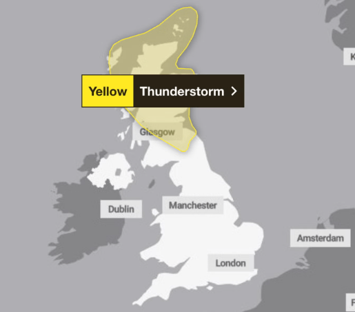
The Met Office has issued yellow weather warnings across parts of Scotland and Northern Ireland, warning of torrential rain, thunderstorms, and travel disruption starting from Wednesday afternoon through to Thursday evening.
“Whilst most areas will remain dry, a few isolated to well-scattered heavy showers and thunderstorms could develop on Wednesday afternoon and evening. The most intense thunderstorms could produce large hail and gusty winds.”
Key Areas Under Alert:
- Wednesday, 2pm–midnight: Aberdeenshire, Dundee, Edinburgh, East Lothian, Glasgow
- Until 10pm Thursday: Central & Eastern Northern Ireland, parts of Scotland
Forecasters caution that up to 50mm of rainfall could fall in certain spots, possibly causing flooding, road closures, and dangerous driving conditions.
“There is a slight chance of power cuts causing loss of service to some homes and businesses. Consider gathering torches and batteries, a mobile phone power pack and other essential items.”
After days of blistering sunshine, the skies are set to crack. Sudden, intense thunderstorms could sweep across the UK, bringing flooding, hail and travel disruption. It’s a sharp U-turn in Britain’s unpredictable summer from sunburn to storm alert.
Health Alerts Extended
In England, heat health warnings have now been stretched into next week. The UK Health Security Agency has extended yellow alerts until 6pm on Sunday, 18 August, across:
- Yorkshire and Humber
- East and West Midlands
- London
- South East and South West
- East of England
These warnings suggest a potential increase in health risks, especially for older adults and those with existing medical conditions. The pressure on health and care services is also expected to rise.
People in vulnerable areas have been urged to prepare flood plans and have emergency kits ready, as there’s a small chance of fast-flowing or deep floodwater posing a risk to life.
Flash floods could cut off communities, particularly in locations known for poor drainage or previous flooding events.
Forecasters are not ruling out further instability. Thunderstorms are likely to linger into Thursday morning, with more slow-moving downpours expected during the afternoon and evening.
Parts of central and eastern Scotland may see up to 60mm of rain within an hour, with risks of surface water flooding. “Showers and thunderstorms should slowly decay during the mid to late evening.”
Looking ahead, the south of England is expected to hold onto sunny and dry weather heading into the weekend. London could see highs of 29°C on both Wednesday and Thursday. Further north, however, conditions may begin to dull, with cloudier skies returning from Monday.
Stay updated with the latest alerts and plan accordingly. Britain’s weather continues to deliver surprises from summer highs to sudden storms.