
The Met Office weather service has warned that large parts of the UK could face a challenging mix of winter conditions this week, as a named storm moves in while freezing Arctic air remains firmly in place.
Forecasters say the combination of snow, ice, heavy rain and strong winds could lead to disruption from Thursday night into Friday, with further unsettled weather expected over the weekend.
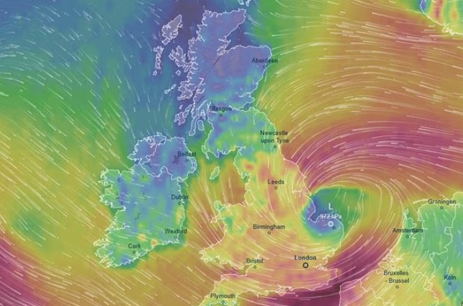
Storm Goretti, named by Météo-France, is forecast to pass close to the southern parts of the UK. While the strongest winds are expected across northern France, the Met Office says the UK will still feel significant impacts due to the storm colliding with unusually cold air.
Why is the Met Office calling this a “multi-hazard” weather event?
The Met Office uses the term multi-hazard when several types of severe weather occur together, increasing overall risk.
In this case, freezing temperatures already affecting the UK will interact with an incoming Atlantic low-pressure system.
That clash means some areas could see snow while others experience heavy rain, all alongside strong winds and a heightened risk of ice.
This type of setup is particularly problematic because conditions can change quickly. Rain can turn to snow with little warning, while melting snow may refreeze overnight, creating black ice on roads and pavements.
When will Storm Goretti affect the UK?
The immediate concern begins overnight into Wednesday, when temperatures are expected to drop below freezing across much of the country.
Storm Goretti has been named by Météo-France and is forecast to bring a mix of rain, sleet, and snow, as well as strong winds, to much of southern England and Wales on Thursday and Friday.
Yellow weather warnings have already been issued.#StormGoretti #TempêteGoretti pic.twitter.com/ksYz3kfWgL
— James Cosgrove (@MrJamesCosgrove) January 6, 2026
The Met Office has warned that icy conditions could develop widely, especially on untreated surfaces during the early morning commute.
The more disruptive phase is expected from Thursday night into Friday. A deepening area of low pressure will move eastwards across the southern parts of the UK, bringing wet and windy weather from the west.
On the northern edge of this system, colder air is likely to turn precipitation into snow, particularly across parts of England and Wales.
Forecasters stress that the exact track of the storm is still uncertain, meaning warnings may change as confidence improves.
Which areas are likely to be most affected?
Northern parts of the UK, including Scotland, remain at risk of further snowfall due to the lingering cold air.
In England and Wales, the Met Office has issued a yellow warning for snow, with accumulations of around 5 to 10 centimetres possible in some places. Higher ground in Wales could see as much as 20 centimetres, making travel difficult.
Meanwhile, southern and south-western areas face the risk of strong winds as Storm Goretti passes nearby.
Gusts of 50 to 60 miles per hour are possible, with exposed coastal locations potentially seeing gusts of up to 70 miles per hour.
These conditions could lead to fallen trees, travel delays and localized power issues.
Ice remains a widespread concern nationwide, particularly overnight and during the early mornings.
What are Met Office forecasters saying?
Met Office Chief Forecaster Jason Kelly highlighted the ongoing ice risk earlier in the week, saying: “Overnight, cold air pushes back in with temperatures widely dipping below freezing again.
This means there is the risk of further ice overnight and a new yellow weather warning for ice covers the majority of the UK until Wednesday morning.”
Looking ahead to later in the week, Deputy Chief Forecaster Chris Bulmer explained why the situation is being closely monitored: “A deepening area of low pressure, named Storm Goretti by Meteo France, will move across the south of the UK during Thursday and into Friday.
It will clash with the very cold air here, meaning Thursday night could be what we call a ‘multi-hazard’ event.”
He added that strong winds could also cause disruption and warned that forecasts may be updated as confidence grows.
How long will the cold weather last?
Temperatures are expected to remain well below average into the weekend. Saturday is likely to be cold but calmer for many, with dry spells and winter sunshine, although wintry showers may continue around northern coasts.
By Sunday, another area of low pressure is forecast to approach from the northwest, bringing rain that could turn to snow in places, along with the risk of strong winds.
This system is expected to introduce milder air from the west, which should gradually bring the current cold spell to an end.
How can people stay informed?
The Met Office is urging the public to keep checking official forecasts and weather warnings, especially if travelling.
Rapid changes in conditions are possible, and even small shifts in the storm’s path could significantly alter impacts at a local level.