Tropical Storm Erin Forecast: Spaghetti Models Reveal Potential Track Twists
Tropical Storm Erin, the fifth named system in the 2025 Atlantic hurricane season, is keeping meteorologists on their toes. New forecast models hint at a possible shift in its projected path.
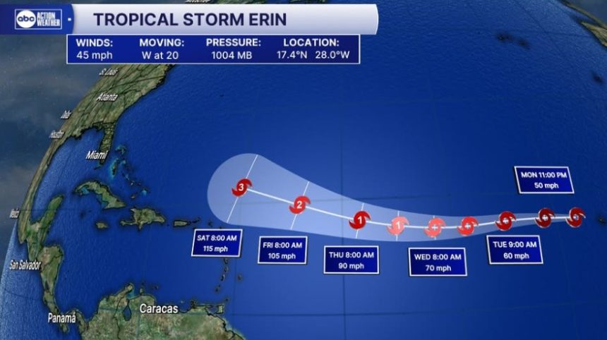
As of Monday evening, Erin was positioned roughly 430 miles west-northwest of Cabo Verde. It’s charging west at around 21 mph, with sustained winds of 45 mph, according to the National Hurricane Center (NHC).
Atmospheric pressure sits near 1004 mb. Forecasters believe the storm could intensify into a hurricane before the week is out.
No coastal watches or warnings have been issued. For now, Erin is well east of the Lesser Antilles, with any closest approach still days away. Model guidance suggests steady strengthening, with the potential for Erin to become the first hurricane of the season by Thursday.
Should this trend continue, the system might reach Category 2 strength over open waters by the weekend.
Spaghetti Models Split on Erin’s Path
Latest spaghetti models, those colourful lines showing multiple computer-generated track projections, are starting to split.
Most show Erin turning northwest, steering clear of land. But a smaller cluster hints at a more westerly course, potentially bringing the storm nearer to the Lesser Antilles later this week.
“Forecast error margins can exceed 125 nautical miles by day four and up to 175 nautical miles by day five,” the NHC noted.
Why the Models Disagree?
This split largely stems from the Bermuda High, a semi-permanent high-pressure system over the Atlantic that tugs tropical systems off course. Even slight shifts in its position or strength can swing Erin’s future path by hundreds of miles.
Add to that the expected arrival of mid-level troughs and upper-level winds, atmospheric elements that could further unsettle the storm’s trajectory.
Historically, Cape Verde storms like Erin are known to intensify rapidly over warm Atlantic waters. But where they end up depends on a volatile dance with the surrounding atmosphere.
Two Main Scenarios
Meteorologists are watching two possible outcomes:
- Northward Bend: The most likely scenario, Erin curves northwest and stays out at sea.
- Westward Push: A less probable track that keeps Erin heading west, edging it toward the Lesser Antilles.
For now, the more westerly path remains an outlier.
Public Advice and Readiness
Experts emphasise that “no immediate threats to land exist” but advise vigilance for residents of the Lesser Antilles, as Erin is slated to become a hurricane later this week. Its exact course will become clearer as more data feeds into the models.
The NHC’s forecast cones and wind probability charts continue to update daily, with fresh details available through the latest storm forecast update. Residents in potentially affected regions are urged to review preparedness plans and stay informed.