
The Met Office has issued a thunderstorm weather warning for Saturday, signalling the start of a wet and unsettled weekend across much of England and Wales.
A yellow warning has been activated, covering southern England, parts of the Midlands, London, eastern regions, and south Wales.
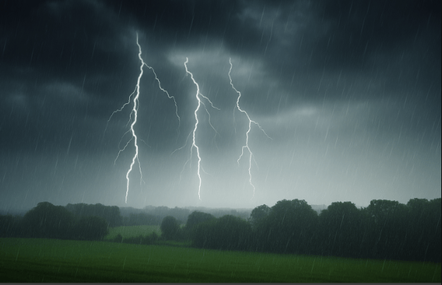
Heavy rain and travel disruption expected as storms hit England and Wales
The warning is in effect throughout Saturday, with frequent downpours and thunderstorms forecast to strike before gradually easing from the west in the late afternoon.
According to the Met Office, 10–15mm of rain could fall within an hour, with some areas receiving up to 40mm over several hours. These bursts of torrential rainfall from successive thunderstorms raise concerns of localised flooding, especially in low-lying urban zones.
“Some places could see 30–40 mm of rain over several hours from successive showers and thunderstorms,” the Met Office stated.
Hazards accompanying the storm include:
- Lightning strikes
- Hail showers
- Strong, gusty winds
These conditions are likely to result in additional safety risks, especially for drivers and those outdoors.
The thunderstorm weather warning brings with it an increased likelihood of disruption to travel. Motorists are advised to plan ahead, as spray and standing water on roads may cause dangerous conditions and longer journey times. Delays to bus and train services are also anticipated.
“Damage to buildings from lightning strikes and short-term loss of power is also likely,” the Met Office warned.
This abrupt change in weather follows what was one of the sunniest and warmest spring starts on record. But Saturday will bring a noticeable drop in temperatures, with:
- London sees lows of 10°C
- Glasgow forecast to reach just 7°C
Between 1 March and 27 May, the UK basked in over 600 hours of sunshine, marking the driest spring in more than 100 years. Now, the nation is facing a sharp contrast as a thunderstorm weather warning dampens weekend plans.
Despite the current gloomy outlook, there’s hope on the horizon. The Met Office’s three-month summer forecast suggests a greater than usual chance of a hot summer, with increased risk of heatwaves and their associated health impacts.
According to forecasters:
- The chance of a hot summer is 2.3 times higher than usual.
- Average summer temperatures range from 10–17°C, with southeast England experiencing the highest averages (16–17°C).
While this weekend may be a washout, Britons are advised to stay weather-aware and take necessary precautions during the thunderstorm weather warning. As always, local updates from the Met Office should be followed closely.