

Storm Chandra is sweeping across the UK today (Tuesday), bringing strong winds, heavy rain, snow, and serious flooding risks, according to the Met Office.
The newly named storm has triggered amber and yellow weather warnings across several regions, with forecasters warning that conditions could become dangerous, particularly in coastal and flood-prone areas.
The storm is already affecting south-west England, Northern Ireland, parts of Wales, Scotland, and northern England, raising concerns about travel disruption, property damage, and risks to life.
Why has Storm Chandra prompted urgent warnings?
The Met Office named Storm Chandra after forecasting a combination of very strong winds and intense rainfall, a mix that significantly increases the risk of flooding and structural damage.
Gusts of up to 75mph are possible in exposed coastal areas, while prolonged rain could overwhelm rivers and drainage systems.
Forecasters say the timing of the storm is especially concerning, as the worst conditions are expected to hit during busy commuting periods.
A Met Office spokesperson said: “Easterly winds will increase early on Tuesday morning, bringing gusts of 60 to 70 miles per hour to eastern and northern parts of Northern Ireland, with a few coastal locations seeing gusts of 75 miles per hour. Heavy rain will be an additional hazard.”
Which areas of the UK are most at risk today?
The most severe conditions are expected in south-west England and eastern Northern Ireland, where amber weather warnings are in force. These alerts indicate a high likelihood of disruption and the potential for harm.
In England, counties including Cornwall, Devon, Somerset, and Dorset face heavy rainfall that could lead to surface water flooding and fast-rising rivers.
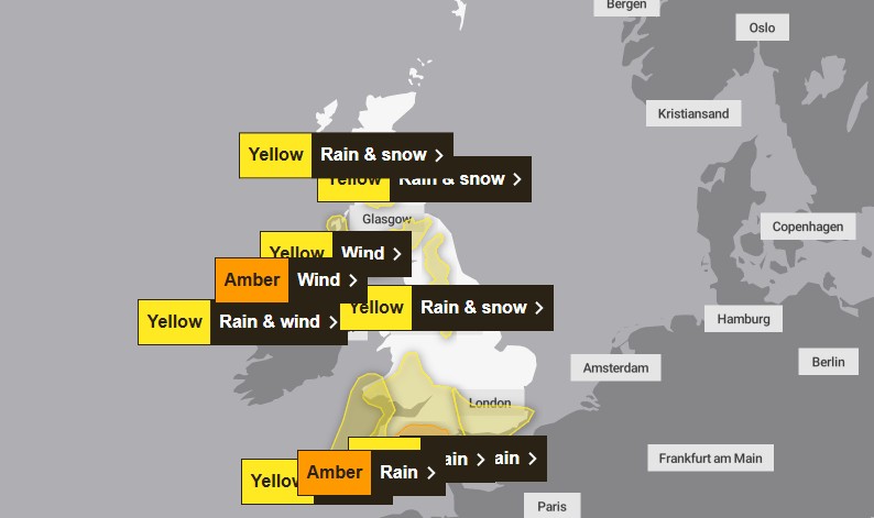
In Northern Ireland, areas such as Derry, County Down, and County Antrim are bracing for damaging winds, particularly along the coast.
Elsewhere, yellow warnings cover all of Northern Ireland and large parts of Wales, Scotland, and northern England.
Some regions, including parts of western Scotland and west Wales, are under overlapping warnings for wind, rain, and snow, increasing the risk of travel disruption.
Why has a ‘danger to life’ flood warning been issued near Exeter?
The Environment Agency has issued a severe flood warning for the River Otter at Ottery St Mary, near Exeter. This is the highest level of flood alert and means flooding is expected and could pose a direct threat to life.
River levels have risen rapidly following persistent rainfall, and residents in nearby areas have been urged to take immediate action, including moving to higher ground and avoiding floodwater entirely.
Severe flood warnings are rare and are only used when conditions are considered extreme.
How dangerous could coastal conditions become?
Along exposed coastlines, Storm Chandra is expected to generate large and powerful waves, driven by strong easterly winds.
The Met Office warns that waves could throw debris onto sea fronts and coastal roads, creating hazardous conditions for pedestrians and drivers.
People walking near cliffs have been advised to take extra care, keep dogs on leads, and avoid coastal paths altogether during the storm.
Even from the shore, large breaking waves can knock people off their feet and pull them into the sea.
In an emergency, the advice remains clear: call 999 and ask for the Coastguard.
How will Storm Chandra affect travel and daily life?
Storm Chandra is expected to cause widespread disruption to transport networks across the UK. Road conditions may deteriorate quickly due to flooding and fallen debris, while rail, ferry, and air services could face delays or cancellations as the day progresses.
The Met Office has advised people to avoid unnecessary travel, particularly during periods of peak wind, and to stay indoors where possible to reduce the risk of injury from flying debris or falling objects.
Power cuts are also possible in some areas, especially where strong winds bring down trees or overhead lines.