

The United Kingdom is bracing for significant atmospheric turbulence as Storm Dave, the fourth named storm of the 2025/26 season, makes landfall this weekend.
The Met Office has issued a series of yellow weather warnings covering Saturday 4 April and Sunday 5 April, citing a “rapidly deepening” low-pressure system fueled by a supercharged Atlantic jet stream.
With gusts expected to reach 90mph in exposed coastal areas of Scotland and up to 20cm of snow forecast for the Highlands, the storm threatens to cause widespread disruption to transport networks, power supplies, and coastal communities.
As the system tracks eastward, heavy rain and gales will sweep across Northern Ireland, Northern England, and North Wales, marking one of the most volatile weather episodes of the year so far.
Why has the Met Office Named ‘Storm Dave’ Now?
Storm Dave was officially named on Thursday after meteorologists identified an explosive cyclogenesis event, often referred to as a “bomb cyclone.”
This occurs when the central pressure of a storm drops by at least 24 millibars in 24 hours. Driven by a powerful jet stream fueled by cold air over North America, the storm is intensifying rapidly as it approaches the British Isles.
Met Office Deputy Chief Forecaster Tom Crabtree explained that the timing is particularly sign
A chilly and bright start for many on Saturday 🌥️
Turning very windy from the west as #StormDave moves in ⚠️
Spells of rain in Northern Ireland and parts of Scotland, otherwise mostly dry ☁️ pic.twitter.com/S4EWtHHDvF
— Met Office (@metoffice) April 3, 2026
ificant: “Storm Dave will form and rapidly deepen on Saturday.
We are seeing a classic ‘sting jet’ signature on satellite imagery, which means localised areas could see wind damage far exceeding the general forecast.”
Which UK Regions Are Facing the Worst of the Weather?
While the entire UK will feel the effects of a blustery weekend, the brunt of Storm Dave’s force is concentrated in the North and West.
The 90mph Danger Zone: Scotland
The entirety of Scotland is under a yellow warning. Specifically, northwest Scotland is bracing for blizzard conditions.
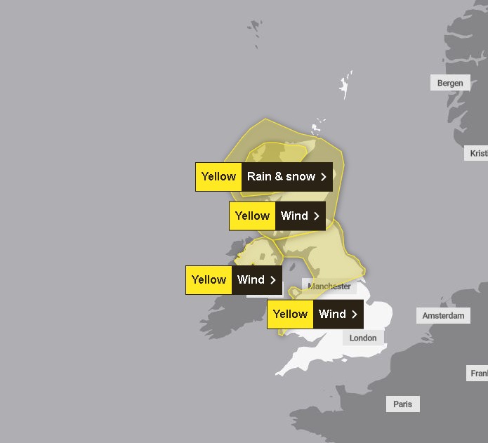
Areas such as Inverness, the Isle of Skye, and the Grampian Mountains are expected to see the heaviest snowfall, with 10–20cm accumulating above 200m. Coastal regions, including Aberdeen and the Hebrides, could see gusts peaking at 80–90mph.
Gale Force Impacts: Northern England & Wales
A broad swathe of Northern England, stretching from Liverpool and Manchester across to Newcastle and Middlesbrough, is under a yellow wind warning.
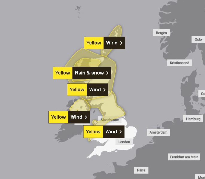
Residents in the Pennines and the Lake District should prepare for difficult driving conditions. Belfast, Derry/Londonderry, and coastal parts of North Wales (including Anglesey) are also facing severe gales.
How is Storm Dave Impacting UK Rail, Roads, and Ferries?
The arrival of the storm during the Easter holiday period has created a “perfect storm” for travel disruption.
- National Rail: Speed restrictions are in place across the West Coast Main Line and ScotRail networks. Rail authorities warn that strong winds can blow trees onto infrastructure, damaging overhead lines.
- Road Safety: The RAC has urged “extreme caution” for high-sided vehicles on exposed routes like the M62 and A1(M).
- Ferries: Services across the Minch and the North Channel (Cairnryan to Belfast) are facing widespread cancellations due to “phenomenal” sea states.
What Official Safety Measures Are Currently in Place?
UK government departments and local agencies have moved to emergency footing:
- The Environment Agency: While the primary threat is wind, flood alerts have been issued for the Cumbrian coast due to storm surges coinciding with high spring tides.
- Power Networks: SSEN and Northern Powergrid have placed hundreds of engineers on standby to deal with potential power cuts caused by falling trees hitting power lines.
- Police Scotland: Drivers of HGVs and buses have been urged to use extreme caution, with some bridges potentially closing to high-sided vehicles if gusts exceed safe limits.
Is the ‘Sting Jet’ Phenomenon Returning to the UK?
Weather analysts are monitoring the storm for a Sting Jet, a narrow, intense beam of wind that can cause catastrophic damage over a small area.
This phenomenon was famously responsible for the damage during the Great Storm of 1987. Should this develop over the North West this afternoon, the Met Office may escalate warnings from Yellow to Amber or even Red.
What Should We Expect After the Storm Clears on Sunday?
As Storm Dave clears into the North Sea late on Sunday, the weather won’t immediately settle.
-
The Big Chill: A “Polar Maritime” air mass will follow the storm, causing temperatures to plummet to -4°C in rural areas.
-
Ice Hazards: Monday morning commuters should expect widespread ice on untreated roads.
-
Clean-up: Local councils will begin the task of clearing debris and assessing structural damage to piers and coastal defenses.