

The latest weather forecast for the United Kingdom indicates a sharp return to colder conditions as forecasters warn of blustery winds, heavy showers and overnight frost.
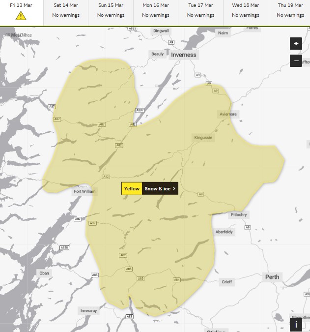
The Met Office has issued a yellow weather warning, cautioning that parts of the country could see wintry showers and icy conditions between Friday, 13 March and Saturday, 14 March.
The change follows yesterday’s wet and windy conditions across much of the UK, as a band of Atlantic rain moved through the country before colder air spread south overnight.
Although many regions will experience brighter weather than in recent days, temperatures will remain low, with strong winds making conditions feel colder.
Northern and western parts of the UK are expected to experience the most unsettled weather, while southern regions may see more sunshine mixed with occasional showers.
Authorities, including the UK Environment Agency and transport operators, are urging residents and commuters to remain cautious, particularly overnight when widespread frost and icy patches are expected to form.
What is happening in the UK weather forecast today?
Meteorologists at the Met Office say the UK is experiencing a shift in atmospheric conditions as a colder air mass moves south across the country.
Friday’s forecast suggests a mix of sunshine and frequent showers, accompanied by strong and sometimes blustery winds. Although the day will be brighter compared with earlier in the week, the colder airflow means temperatures will remain below seasonal averages in several regions.
Forecasters have highlighted the potential for locally heavy showers, particularly in the north and west of the UK. Some of these showers may become wintry, especially over higher ground where colder air temperatures increase the likelihood of sleet or snow.
By evening, the number of showers is expected to gradually reduce in many areas, though northwestern regions could still experience scattered rainfall.
Which parts of the UK will be most affected by the weather warning?
The unsettled conditions are expected to impact several regions, though the most significant weather is forecast in northern and western areas.
Scotland and northern England
Areas of Scotland and northern England may experience heavy showers and occasional wintry precipitation, especially in higher ground.
⚠️YELLOW WEATHER WARNING⚠️
The @metoffice has issued a 🟡YELLOW🟡 weather warning for ❄️SNOW and ICE❄️on the morning of Friday 13th March
🔗More details can be found here: https://t.co/2YFG8JFt6o
🔗Safety tips: https://t.co/p8TW4Em0cQ pic.twitter.com/mOXvJLzTL2
— Traffic Scotland (@trafficscotland) March 12, 2026
Wales and Northern Ireland
Both Wales and Northern Ireland are likely to see frequent showers and gusty winds throughout the day.
Major cities likely to experience showers
Cities including Manchester, Liverpool, Leeds and Glasgow could see intermittent rain throughout Friday. Meanwhile, southern areas such as London may experience brighter intervals between occasional showers.
What have UK authorities said about the weather warning?
Officials from the Met Office have advised the public to prepare for rapidly changing weather conditions.
According to the Met Office forecast update: “Friday will generally be a brighter day than of late, though with a cold and sometimes blustery wind blowing. There will also be some showers, these most widespread in the north and west, where locally heavy and in places wintry.”
The forecast also highlights the risk of widespread frost overnight, which may result in icy patches forming on untreated roads and pavements.
Meanwhile, the UK Environment Agency is monitoring rainfall levels in western regions to ensure river levels remain stable.
Transport authorities such as Transport for London have advised commuters to check travel updates, particularly early on Saturday morning when icy surfaces may pose risks.
How could the weather affect commuters and residents?
The combination of strong winds, heavy showers and overnight frost could affect daily life across the UK.
Motorists are being urged to take extra care on the roads as sudden downpours may reduce visibility, and overnight freezing temperatures could lead to icy surfaces.
Drivers should remain cautious of:
- Water pooling on roads after heavy showers
- Reduced visibility during sudden rain bursts
- Ice forming overnight on untreated surfaces
Public transport networks may also experience minor disruptions, particularly in northern areas where heavier showers are expected.
Commuters travelling through cities such as Birmingham, Leeds and Glasgow are encouraged to check travel information before setting out.
Health officials from the NHS also recommend that vulnerable individuals take precautions against cold temperatures by dressing warmly and avoiding slippery pavements.
What will the UK weather be like tomorrow?
Looking ahead to Saturday, forecasters expect the weather to remain somewhat unsettled, though conditions should gradually improve.
After a cold start with widespread frost, Saturday will bring:
- Intervals of sunshine across many regions
- Scattered showers, mainly in northwestern areas
- Lighter winds compared with Friday
- Slightly milder daytime temperatures
Despite these improvements, meteorologists say the overall weather pattern remains changeable as Atlantic systems continue to influence the UK climate.
The Met Office suggests that March is likely to bring alternating periods of sunshine, showers and occasional colder spells as the country transitions from winter into spring.
FAQ: UK Weather Forecast
Why has a yellow weather warning been issued?
The Met Office issued the warning due to cold winds, heavy showers and the risk of overnight frost, which may cause hazardous travel conditions.
Which parts of the UK will experience the worst weather?
Northern and western areas, including Scotland, Wales, Northern Ireland and northwest England, are expected to see the most frequent and heavy showers.
Will snow fall in the UK this week?
Most areas will see rain showers, but higher ground in Scotland and northern England could briefly see sleet or snow.
Will the weather improve this weekend?
Saturday should bring more sunshine and lighter winds, although scattered showers are still expected in northwestern regions.