

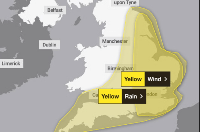
Britain is bracing for a turbulent Thursday as the Met Office rolls out yellow weather warnings across vast areas of the country. Gusts nearing 75mph and relentless downpours are set to sweep across parts of England and Wales, sparking warnings of power outages, property damage, and potential risk to life.
Coastal Havoc Looms as Fierce Winds and Torrential Rain Target UK
Eastern England is in the storm’s firing line, with forecasters issuing stark alerts over the scale of wind expected. Beachfronts, coastal roads, and seaside homes could all bear the brunt.
“Gusts of wind of 45-55 mph can be expected widely, with 65 mph possible near coasts. There is a smaller chance that wind gusts of 65-75 mph may develop for a time very locally, this most likely late morning and into the afternoon,” the Met Office warned.
Flood Threat Rising with Heavy Rainfall in the Forecast
It’s not just the wind that’s cause for concern. Heavy rain is also expected to lash southern and eastern England, as well as parts of south Wales. The Met Office has warned that flash flooding could affect homes, roads, and local businesses.
Some regions may see up to 50mm of rain during the morning rush, especially across South West England.
“There is a small chance a few places could exceed this, most likely over North Devon and Cornwall and more generally in the east of the highlighted area,” forecasters added.
Brace for travel disruption, coastal chaos, and localised flooding as Britain faces a stormy Thursday. With 75mph gusts and torrents of rain set to hit, authorities are urging the public to stay alert and avoid unnecessary risks.
Travel Disruption and Safety Risks Ahead
The incoming storm system is expected to trigger widespread travel headaches. High-sided vehicles may struggle on exposed roads, and ferry crossings could face delays or cancellations. Commuters are being urged to check travel updates regularly and plan ahead.
“Conditions are expected to turn windy with a chance of gales, initially along southern and eastern coasts, but more widely across southern Britain during Thursday daytime,”
The Met Office continued.
What to Expect Key Impacts:
- Power outages in exposed and rural areas
- Large waves are potentially sweeping debris onto roads and seafronts
- Flooding in low-lying areas and near rivers
- Hazardous driving conditions for motorists
Public Urged to Take Precautions
Emergency services and local councils are on standby, with sandbags and flood barriers already being prepared in vulnerable areas. Residents near the coast are being warned to stay clear of the shoreline during peak storm hours.
While these kinds of autumn storms are not uncommon in the UK, the combination of wind speeds and rainfall totals has raised concern among weather experts.
Conditions are expected to improve heading into the weekend, but lingering showers and breezy weather may persist into Friday. Authorities advise keeping an eye on updates and following safety guidance throughout the next 48 hours.
Stay indoors where possible, secure outdoor items, and avoid exposed coastal spots. For those travelling, it’s best to delay non-essential journeys until the storm passes.
This weather update is part of our ongoing coverage of severe UK weather events. Keep following the UK News Blog for the latest updates and safety tips.