
UK Heatwave Set to Scorch at 34°C Weather Maps Reveal Peak Date
Britain is bracing for yet another heat wave, with forecasters warning that temperatures could soar to 34°C in the coming days.
If predictions hold true, this will be the fourth official heatwave of the summer, a reminder that 2025 has been no stranger to sweltering conditions.
For an official declaration, the mercury must stay above a region’s heatwave threshold, between 25°C and 28°C, for three straight days. And according to experts, that could happen as soon as Tuesday.
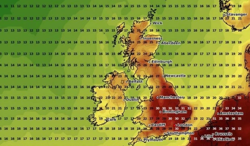
Weather models are painting a sizzling picture. The GFS charts suggest parts of southern England could hit 31°C by 6pm today. London looks set for 30°C, the Midlands close behind at 29°C, and the north of England touching 26°C.
Tuesday appears to be the real scorcher. Gloucester could see the top figure of 34°C, while widespread highs of 31°C to 33°C are expected across southern and central England and much of Wales. Scotland may climb to 26°C, and Northern Ireland is likely to see 24°C.
By Wednesday, the focus shifts to central and eastern England. Highs between 30°C and 32°C are on the cards, with London once again forecast to touch 30°C.
Greg Dewhurst, senior meteorologist at the Met Office, explained: “Temperatures are going to rise over the coming days, particularly across England and Wales, but it is not going to be felt quite as much across parts of Northern Ireland and Scotland – it’s not going to be widespread heat everywhere.
And the reason for that is we’ve got high pressure to the south east of the UK at the moment and low pressure to the north west and west.
But through Monday, we start importing some of that hot and humid air, and we’re looking at highs of around 31C across central and southern England, with the rest of England and Wales getting towards the high 20s, and Northern Ireland and parts of Scotland in the low 20s.
The heat may spark one or two heavy showers and thunderstorms across south-west England and Wales, but they’ll be very isolated.
And then Tuesday looks largely dry, with plenty of sunny spells – it could well be the peak of the heat.
Temperatures are set to rise to about 33C across central and southern England, but again, this could spark off a thunderstorm by the afternoon and evening time.
And some places will hit heatwave thresholds on Tuesday, while some places will hit it on Wednesday – it depends on the area.”
The sudden surge in heat will likely push parts of England and Wales straight into heatwave territory. While many will relish the sunshine, meteorologists have warned of possible short-lived thunderstorms breaking the dry spell.
As Britain prepares for the searing days ahead, the message is clear – keep cool, stay hydrated, and brace for a summer sky set on turning up the heat.