
Tropical Storm Erin Forecast: Monitoring Storms in Southeast Louisiana
Tropical Storm Erin is being closely monitored this week, expected to strengthen into the season’s first hurricane by the weekend. Meanwhile, scattered storms fueled by tropical humidity will impact Southeast Louisiana over the next couple of days.
In the Gulf and Beyond
A weak low-pressure system lingers off Florida’s coast in the Northeastern Gulf. Although it won’t develop further, heavy rain and possible flooding may affect the Florida Panhandle shortly. Officials say there is almost no chance of this system developing into a tropical storm over the next several days.
On the Atlantic Front
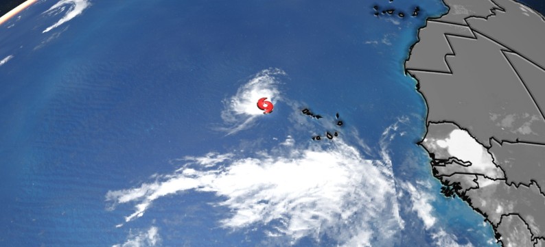
Out in the Central Atlantic, a disorganised cluster of showers known as Invest 96L drifts northwards. The National Hurricane Center (NHC) warns that significant development is unlikely, with only a 10% chance of formation within the week.
A third system, south-southeast of Nova Scotia, currently non-tropical, could briefly develop into a tropical or subtropical storm as it crosses the warm Gulf Stream. However, cooler waters midweek will most likely end its chances of intensifying.
Thankfully, none of these systems pose any direct threat to Southeast Louisiana.
Local Weather Outlook
Expect a wet couple of days in Southeast Louisiana. “Storms are likely the next two days as a surge of tropical humidity has moved into Southeast Louisiana.
Rain could arrive as early as daybreak,” meteorologists report. Temperatures will hover between 88 and 90 degrees Fahrenheit, with high humidity keeping storm activity persistent through Wednesday.
By the end of the week, the rain should ease, but heat will return with a vengeance. Temperatures may rise to 95 degrees with heat indexes reaching as high as 109, prompting potential Heat Advisories for the weekend. WDSU First Warning Weather Impact Days could be activated as a precaution.
Seven-Day Summary:
-
Tuesday: Storms likely throughout the day.
-
Wednesday: Scattered storms continue.
-
Thursday to Sunday: Storm activity decreases, with isolated showers expected. Heat intensifies heading into the weekend.
Keep an eye on Tropical Storm Erin as it develops — this could be the first hurricane to mark the start of a busy season. Stay safe and prepared.