

The UK is preparing for another bout of severe weather as Storm Floris is forecast to sweep in on Monday, bringing winds of up to 85mph and widespread disruption across parts of the country.
Northern England and Scotland are expected to bear the brunt of the storm, with strong gusts and driving rain prompting the Met Office to issue both yellow and amber wind warnings.
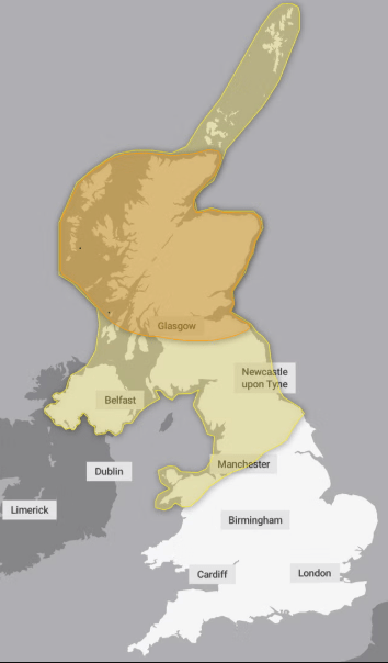
Weather Warnings in Place
The yellow warning, which spans Northern Ireland, north Wales, northern England and parts of Scotland, indicates possible disruptions to travel and outdoor activities.
Meanwhile, an amber warning has been issued for the northern Scottish mainland, where wind speeds are expected to reach hazardous levels.
The Met Office has cautioned that these powerful gusts could pose a serious threat. The yellow warning is active from 6am on Monday until midnight, while the amber warning will be in place between 10am and 10pm.
“Across the warning area, many inland areas are likely to see gusts of 40-50mph, with 60-70mph more likely at higher elevations and around exposed coasts in Scotland.
There is a small chance that some locations here could even record gusts of 85mph,” said Matthew Lehnert, Met Office chief meteorologist.
Storm Floris marks the sixth named storm of the 2024-25 season and comes on the back of an extraordinary summer marked by record-breaking heat and extreme weather fluctuations.
Severe Impacts Expected
The storm is expected to disrupt road, rail, air and ferry services. Power cuts are likely in affected areas, and exposed structures such as roofs may suffer damage, with the potential for tiles to be dislodged. Flying debris and large waves pose significant dangers along coastal routes.
The Met Office warned: “Large waves and beach material being thrown onto sea fronts, coastal roads and properties” could cause injuries and pose a danger to life.
As the storm moves eastward into Tuesday, strong winds will persist in the affected regions, though conditions will gradually ease from the west as Monday progresses.
Recent Weather Extremes
Storm Floris arrives following one of the driest springs in over a century and a series of three rapid-fire heatwaves. June shattered temperature records, becoming the warmest month since data collection began.
Farmers, grappling with the effects of extreme heat, were forced to harvest early to prevent crop damage, sparking concerns over future food supplies. Hosepipe bans were imposed in several areas due to water shortages.
Last month also stood out for its heat, with July becoming the fifth warmest on record in the UK. The average temperature hit 16.8°C, placing it just behind 2006 (17.8°C), 2018 (17.2°C), 1983 (17.1°C), and 2013 (17°C).
Each of the four UK nations recorded one of their ten warmest Julys since records began in 1884:
- Scotland and Northern Ireland saw their sixth warmest
- England reported its seventh
- Wales had its tenth
Yet, despite the warmth, July ended on a much wetter note. Torrential downpours triggered flood alerts in the Midlands, southern and eastern England, and London last Thursday. Days earlier, temperatures had soared to a balmy 28°C.
The weekend leading into Storm Floris is expected to remain relatively dry, according to the latest Met Office updates, with only minimal cloud cover forecast. However, come Monday, the nation must prepare for a return to turbulent weather.
With strong gusts, driving rain, and travel disruption likely, residents in the affected regions are urged to stay informed and take necessary precautions.