
The Met Office has issued a snow alert for parts of the UK as wintry conditions return after a long spell of wet and unsettled weather.
Forecasters say snow and ice will affect Scotland and northern England from Thursday afternoon into Friday, with temperatures dropping sharply as Arctic air pushes south.
The warning matters because it increases the risk of travel disruption, dangerous driving conditions, and icy pavements, particularly overnight.
People commuting early on Friday, as well as older residents and those with health conditions, could feel the biggest impact.
Where have Met Office weather warnings for snow been issued?
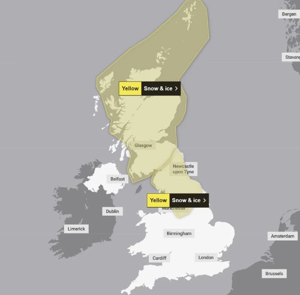
The Met Office has confirmed yellow weather warnings for snow and ice covering large parts of Scotland and northern England. The warning runs from 4pm on Thursday until 12pm on Friday.
Forecasters expect rain to arrive first, but colder air will quickly turn it into snow, especially on hills and higher routes. As temperatures continue to fall through Thursday night, snow could spread to lower ground in some areas.
Meteorologists say snow is most likely to settle above 200 metres, and some higher locations could see up to 10cm. Lower areas may see slushy conditions, but the risk of ice will remain high even if snowfall stays light.
Why is snow arriving after so much rain?
The UK has seen repeated spells of rain in recent weeks, leaving ground conditions extremely saturated. Now, a shift in the weather pattern will drag cold Arctic air across the country, replacing the milder air that has dominated much of winter so far.
This is a dangerous combination. Wet roads and pavements freeze faster when temperatures drop suddenly, and the moisture left behind by heavy rain makes ice formation more likely.
Even where snow does not settle, water on untreated surfaces can freeze overnight and create hidden hazards by early morning.
How cold will the UK get during this warning period?
Forecasters expect temperatures to fall to around 3°C to 6°C below average in parts of the north.
Daytime temperatures may hover just above freezing in some areas, but the sharpest drop is expected overnight into Friday morning.
That is when many regions could see temperatures close to 0°C, increasing the risk of black ice, especially on rural roads and high routes.
Even in towns and cities, pavements could become slippery quickly, particularly where rainwater sits in shaded areas and freezes after dark.
Will the snow and ice cause travel disruption?
Yes, disruption is possible, especially for drivers and commuters travelling early on Friday.
Snowfall on higher ground could slow traffic and reduce visibility, while icy conditions may lead to skidding incidents on untreated roads.
Bridges and flyovers often freeze first, and roads running through exposed countryside can become dangerous within minutes if snow begins settling.
Public transport may also feel the knock-on effects. Bus routes can face delays if roads become difficult to navigate, and rail services sometimes run more slowly during icy conditions to reduce risk on tracks and junctions.
Although this is a yellow warning rather than a severe amber alert, the Met Office warning system is designed to highlight the possibility of disruption before it escalates.
What does a yellow snow and ice warning actually mean?
A yellow warning is the Met Office’s way of saying the weather may cause disruption, but the impact will vary depending on local conditions.
In practical terms, it means people should expect the possibility of slower journeys, minor delays, and a higher risk of accidents.
It also signals a greater chance of injuries caused by slips and falls, especially on untreated pavements outside homes, shops, and workplaces.
Yellow warnings are common in winter, but they still deserve attention. Even small temperature drops can turn a normal morning commute into a dangerous one if ice forms overnight.
Is ice more dangerous than snow in this forecast?
In many cases, yes. Ice often causes more problems than snow because it can form without being seen.
Black ice is particularly risky because it blends into the road surface and can catch drivers and pedestrians off guard. After a wet day, temperatures can drop quickly overnight and refreeze water on pavements, car parks, and side streets.
This means some areas may experience hazardous conditions even if snowfall remains light or patchy. In short, the biggest danger may come after the snow clears, when temperatures fall further, and untreated surfaces freeze.
Are health warnings also in place because of the cold snap?
Health officials have issued cold weather alerts for parts of England, particularly in northern regions and the Midlands, as temperatures are expected to drop below seasonal averages.
Cold weather increases health risks for vulnerable people, including older residents and those with heart or breathing problems. It can also raise pressure on NHS services, especially if icy conditions lead to falls and injuries.
“Cold weather can increase pressure on health services and raise risks for vulnerable people,” officials warned in seasonal guidance.
The warning is especially relevant for households struggling to keep homes warm, as a sudden drop in temperature can increase heating costs and worsen existing health conditions.
Why did this weather change hit commuters and households?
Short cold snaps often create bigger disruptions than people expect, particularly in the north of England and Scotland, where roads run through higher and more exposed ground.
For example, routes across Cumbria, the Pennines, and parts of the Scottish Highlands can quickly become difficult if snow begins settling above 200 metres.
Even major commuter routes can be affected if ice forms overnight and traffic builds up during the morning rush.
For households, the issue is not just snow. A sudden temperature drop after weeks of rain can increase damp and cold indoors, forcing people to use heating more heavily at a time when many already feel financial pressure.
Will the weather improve after Friday?
Forecasters expect conditions to clear southwards early on Friday, bringing brighter spells and sunshine for some areas through Saturday.
However, the improvement may not last. Weather models suggest more rain could return later in the weekend, and there is a chance of temporary snow on higher ground again before it turns back to rain.
With the ground already saturated, further heavy rainfall could increase the risk of localised flooding, meaning additional weather warnings remain possible in the days ahead.