
The United Kingdom is currently caught in a dramatic meteorological standoff this weekend, Saturday 25 April to Sunday 26 April 2026, as record-challenging spring warmth in the west clashes with a stubborn blanket of haar and low cloud in the east.
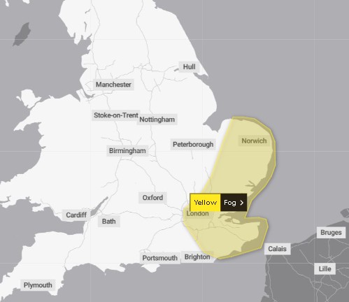
While many Britons are reaching for sunscreen, the Met Office has officially triggered a Yellow weather warning for Saturday, highlighting significant risks to travel and visibility.
The “split-screen” weather conditions are being driven by a powerful high-pressure system positioned over Scandinavia, which is funnelling warm continental air across the UK while simultaneously dragging moisture-laden North Sea fog onto the eastern seaboard.
Why has the Met Office issued a Yellow Warning today?
The Met Office has designated Saturday, 25 April, as a day of potential disruption. The primary concern is visibility.
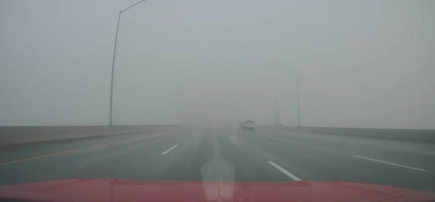
As warm air from the west meets the cold North Sea surface, dense fog patches have developed. The warning specifically covers parts of the East of England, Northeast England, and Eastern Scotland.
⚠️ Yellow weather warning issued ⚠️
Fog East Anglia and southeast England
Saturday 0400 – Saturday 0800
Latest info 👉 https://t.co/QwDLMfRBfs
Stay #WeatherAware⚠️ pic.twitter.com/JmTuFa3SOZ
— Met Office (@metoffice) April 25, 2026
The official forecast notes that early morning fog will clear slowly, leaving “low cloud and patchy drizzle” confined to eastern Scotland and northeast England.
For motorists, this creates treacherous driving conditions, with visibility dropping below 100 metres on major routes such as the A1(M) and the A90 north of the border.
Where is the best of the sunshine this weekend?
In a stark contrast to the misty east, the majority of the UK is enjoying what meteorologists describe as Very Warm settled conditions.
- The “Sun Belts”: Central and Western England, Wales, and Northern Ireland are the weekend’s winners. Locations like Cardiff, Bristol, and Manchester are seeing clear blue skies and light winds.
- Temperature Extremes: While eastern coastal towns like St Andrews and Scarborough may struggle to get above 11°C or 12°C, sheltered inland spots in the west could see the mercury climb to 22°C, well above the April average.
- Northern Ireland: Despite “isolated showers” forecasted for Saturday afternoon, particularly around Counties Antrim and Down, much of the region remains pleasantly warm.
What do the experts and authorities say?
The Met Office spokesperson, in a briefing today, emphasised the localised nature of the warnings: “The high pressure is incredibly robust, but the ‘North Sea Fret’ is equally stubborn.
We expect a clear divide: if you can see the sea in the east, you’re likely in the cloud; if you’re inland or in the west, it’s a summer-like day.”
National Highways has issued a travel advisory for the M25, M11, and A1, urging drivers to use fog lights where necessary and maintain increased following distances.
Meanwhile, the UK Health Security Agency (UKHSA) has reminded residents in the sunnier west to be mindful of UV levels, which are surprisingly high for late April.
How will this affect UK transport and commuters?
Despite the weekend timing, the weather is having a tangible impact on the UK’s infrastructure:
- Road Safety: The RAC has reported a spike in “minor shunts” in the Northeast due to the sudden onset of sea fog.
- Aviation: Edinburgh Airport and Newcastle International have closely monitored visibility, with some “holding patterns” reported for early-morning arrivals on Saturday.
- Coastal Tourism: Businesses in Brighton and Bournemouth are reporting record footfall, whereas eastern resorts like Skegness are seeing a slower start to the weekend as the “chilly” feel persists.
Is the “Warm Spell” set to continue into Sunday?
The outlook for Sunday, 26 April, suggests a slight shift in the pattern. The Met Office predicts:
- Morning: Any lingering low cloud and fog in the east will lift more rapidly than on Saturday.
- Afternoon: Most of England and Wales will transition into “warm hazy sunshine.”
- The Change: However, Scotland and Northern Ireland will become “cloudier with showers,” as a weak weather front approaches from the Atlantic. This could bring “isolated showers” further south into England by Sunday evening.
Safety Checklist: Navigating the Weekend Weather
If you are travelling or planning outdoor events, authorities recommend the following:
- Visibility Check: If driving through the Yellow warning zones, ensure your fog lights are operational. Do not rely on automatic DRLs (Daytime Running Lights).
- UV Protection: In the West, the “hazy” nature of the sun can be deceptive. High SPF is recommended.
- Hydration: With temperatures hitting 22°C in some areas, the NHS suggests increasing fluid intake, particularly for the elderly and vulnerable.