
A striking new weather map suggests snow could return to several regions of the UK later this week, with blizzard-like conditions expected from Thursday into Friday.
Forecasters are warning that a sudden drop in temperatures, combined with gale-force winds, could create hazardous travel conditions across South Wales, the Midlands, and parts of North West England.
What Areas Are Most at Risk of Snow This Week?
According to the latest meteorological analysis, the following regions are forecast to see snowfall:
| Region | Expected Timing | Notes |
|---|---|---|
| South Wales | Thursday evening – Friday morning | Blizzard-like gusts, particularly along coasts |
| Gloucestershire | Thursday night – Friday morning | Snow mixed with rain, possible icy patches |
| Midlands (various counties) | Friday morning | Localised snow showers |
| North West England (Lancashire, Cumbria) | Thursday night – Friday | Coastal wind chill, gusts up to 60mph |
| North East England | Friday | Scattered snow showers |
Tyndrum in Stirling received over 43mm of rain on Sunday, demonstrating the potential for flooding in low-lying areas already susceptible to snow.
How Severe Will the Weather Be?
While much of the week has seen relatively mild temperatures, Bude in Cornwall reached 12.9°C earlier this week — forecasters predict a sharp temperature drop on Thursday.
Gale-force winds, particularly along the western Welsh coast and Lancashire’s seafront, could produce wind chills making it feel significantly colder than the mercury suggests.
The Met Office notes: “After a frosty start, Wednesday should be dry and bright but chilly. Wet and windy weather pushing northeastwards through Thursday, followed by blustery showers on Friday.”
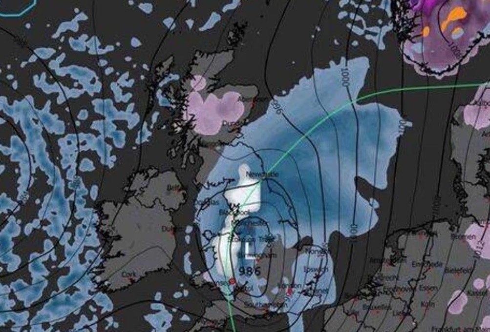
However, specialist weather charts from Metdesk for WXCharts indicate a more extreme scenario, with large white zones covering Wales, Lancashire, Cumbria, and parts of Northeast England, signalling an impending snow event.
Are Flood Risks Increasing Alongside the Snow?
Yes. Authorities are keeping a close eye on rivers and low-lying areas due to heavy rainfall over the weekend. The Environment Agency has reported raised water levels at:
- River Severn at Severn Ham, Tewkesbury, Gloucestershire
- South Winterbourne Valley, Dorset
Localised flooding may coincide with snowfall, particularly near the River Teme at Stanford Bridge, Worcestershire, which has been flagged as especially vulnerable.
What Does This Mean for Travel and Daily Life?
- Roads: Snow and ice could make driving treacherous, especially on rural routes and elevated roads.
- Public transport: Expect delays on trains and buses, particularly in affected areas.
- Power supply: High winds could bring down trees and power lines, causing temporary outages.
- Advice: Local councils recommend keeping a snow kit in your car and checking live Met Office updates.
Will the Snow Last Into the Weekend?
The Met Office forecasts that conditions will remain changeable after the initial snowfall:
“Further areas of low pressure moving in from the Atlantic will tend to dominate, meaning showers or longer spells of rain for many parts. Wet weather will probably be most prevalent across western areas, though heavy rain is possible anywhere at times.”
Windy periods are expected to continue intermittently, with some drier spells mainly in eastern regions. Residents should remain alert to shifting conditions.