
Hurricane Erin: UK Braces for 1,000 km ‘Wall of Rain’ as Storm Moves Across Atlantic
Britain is on alert as the after-effects of Hurricane Erin edge closer, with experts warning of a dramatic shift in weather. Reports suggest a colossal 1,000-kilometre-long “wall of rain” could sweep across the west, dousing the country after an extended heatwave.
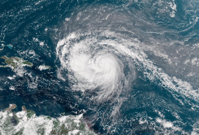
Already, Erin has wreaked havoc across the United States. It strengthened swiftly to Category Four, prompting a state of emergency in North Carolina. Rescue operations are underway as 20-foot waves crash ashore and nearly 38,000 people are evacuated.
“Erin’s already large size and intensity are acting like a giant plunger on the sea surface,” says AccuWeather senior meteorologist Alex Sosnowski.
Remarkably, the storm leapt from tropical storm straight to Category Five in just over 27 hours, making it one of the fastest-strengthening storms recorded. It has since eased slightly to Category Four.
While the hurricane won’t hit Britain head-on, its remnants are expected to deliver blustery winds and heavy rain across southern and western regions.
A Met Office spokesperson told the Daily Mail: “A deep area of low pressure linked to Erin is likely to develop in the North Atlantic, with the final week of August possibly seeing Atlantic systems progress over the UK, especially in the North and West.”
To clarify the much-talked-about “wall of rain”, meteorologist Simon King explained to the BBC it’s not a physical barrier, but a vast low-pressure system spanning 600 miles.
“Any low-pressure containing remains of the strong storm would be 600 miles wide,” he said. In layman’s terms, that means the sizzling 30 °C days London has been enjoying could soon give way to steady downpours and thunder.
Meanwhile, across the Atlantic, Erin is already making its presence felt. The Bahamas and Turks and Caicos are receiving relentless rain, while America’s East Coast braces for dangerous seas. North Carolina is managing evacuations amid surging waves.
As for the UK, the eventual impact hinges on how Erin evolves as it drifts through the North Atlantic, with the Met Office tracking Hurricane Erin closely to assess the risk here at home.
One thing seems increasingly certain: Britain’s late-summer heatwave may be running out of time. The Bank Holiday weekend, once promised sunshine, may now need umbrellas instead of barbecues.
Hurricane Erin is steering our weather one way or another, and the countdown has begun.