

The United Kingdom is currently undergoing one of the most violent atmospheric shifts in recent memory.
After basking in an extraordinary 26.5°C at Kew Gardens on Wednesday, making it the hottest day of 2026 and the warmest early April spell since 1946, the “plume” of continental air is being aggressively pushed out by a North Atlantic cold front.
Today, Thursday, 9 April, marks the beginning of a “seasonal shock” for millions of Britons. The Met Office has confirmed that temperatures will plummet by as much as 10°C to 12°C in less than 24 hours, transitioning the nation from mid-summer warmth back to a biting spring chill.
Why has the UK Temperature Dropped So Sharply?
The current weather phenomenon is a classic “clash of air masses.” For the first half of the week, a southerly flow dragged air from Iberia and North Africa across the British Isles.
This peaked on Wednesday, with London and the Home Counties seeing temperatures more typical of July than April.
As of this morning, a robust cold front is slicing through the UK from the northwest. Behind this front lies polar maritime air originating near Greenland.
Sunshine in southeast England turning hazy through Thursday morning with cloudier skies elsewhere and showery rain, locally heavy in the north 🌧️
Skies brightening with sunny spells and heavy showers in western Scotland and Northern Ireland 🌦️🌈
Turning blustery and colder 📉 pic.twitter.com/sRWqagLRCH
— Met Office (@metoffice) April 8, 2026
This transition is triggering a “reinvigoration” of weather systems, turning gentle breezes into blustery gales and replacing clear skies with a band of organized, heavy rain.
Which UK Regions are Most Affected by the Cold Snap?
The “weather divide” today is stark, with the cold air progressively “winning” as it moves southeast.
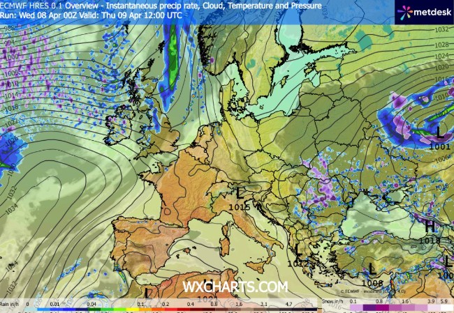
- Scotland and the Highlands: The transition is already complete here. In Aberdeenshire, temperatures have plummeted from 18°C on Wednesday to just 8°C today. Wintry showers, including sleet and snow, are affecting high-level routes like the A9 and the Cairngorms passes.
- Northern England and the Midlands: Cities such as Manchester, Leeds, and Birmingham are seeing a dramatic shift. Rainfall is heavy at times, accompanied by a biting wind that makes the 11°C forecast feel closer to 6°C.
- London and the Southeast: This region is the last to lose the warmth. While the morning started mild, the cold front will arrive by the afternoon, bringing a sharp “step-change” in conditions and potentially thunderous downpours.
- Northern Ireland: After a breezy start, Belfast and surrounding counties will see some of the most unsettled conditions on Friday as a new low-pressure system brings coastal gales.
What the Met Office and Agencies are Saying
The Met Office has urged the public to stay “Weather Aware” as the transition could catch many off guard, particularly those who have packed away winter clothing during the mid-week heat.
“The contrast with Wednesday’s warmth is particularly marked. We are moving into a much more unsettled regime. While the heat was exceptional, the coming days will feel notably raw, especially in the wind,” a Met Office meteorologist noted.
National Rail and National Highways have issued precautionary advice for those traveling on Friday, 10 April. The forecast for coastal gales in the west could lead to restrictions on exposed bridges, such as the Britannia Bridge in Wales and the M48 Severn Bridge.
Additionally, the UK Health Security Agency (UKHSA) continues to monitor the “Very High” pollen levels.
While the rain may temporarily dampen the count, the strengthening winds expected on Friday will likely keep the “Red Alert” for Birch and Ash pollen active across England.
The Public Impact
This 48-hour shift is more than just a change in wardrobe; it has significant implications for UK infrastructure:
- Transport Disruptions: Heavy rain on Thursday is expected to create “spray and standing water” on major motorways like the M1 and M6. Commuters are warned of potential delays during the Thursday evening rush hour.
- The “Easter Holiday” Factor: With many schools on break, tourist hotspots in the Lake District and Cornwall are seeing a mass exodus from campsites as the weather turns “unfit for canvas.”
- Energy Consumption: After a rare three-day period where UK domestic heating demand plummeted, the “patchy rural frost” forecast for Thursday night is expected to see a sharp surge in gas and electricity usage as households reactivate boilers.
- Agriculture: The sudden return of wintry showers in the north is a concern for the lambing season. Farmers in Cumbria and North Yorkshire are being advised to move vulnerable livestock to sheltered ground.
Will the Weekend Bring Any Relief?
The forecast for Friday, 10 April and the following weekend suggests the “unsettled” theme is here to stay.
A deepening low-pressure system in the Atlantic is tracking toward the Western Isles and Northern Ireland. On Friday, this will bring a second wave of heavy rain and much stronger winds. While the extreme 26°C heat is gone, the weekend will see a “seesaw” of temperatures, staying mostly in the low teens—closer to the UK’s long-term April average of 13°C.