
As Brits prepare to turn back their clocks this weekend, they’ll also need to brace for a wintry blast. The Met Office has warned that plummeting temperatures and biting winds will make this weekend the coldest of the season so far, with snow expected to dust parts of the country.
Snow and Frost to Hit UK as Temperatures Plummet
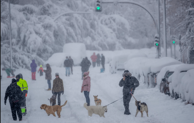
A rush of cold air from the Arctic is heading towards the UK, bringing with it a sharp drop in temperatures and the season’s first snowfall.
According to the Met Office, snow showers are likely to hit the Scottish Highlands on Saturday, while many across England and northern Scotland will wake up to a “patchy frost” on Sunday.
Temperatures are forecast to sink into single digits, and with strong winds thrown into the mix, it’s going to feel even colder than the thermometer suggests.
“The combination of strong breezes and incoming, colder air means it will feel raw in exposed spots through daylight hours,” said the Met Office.
Saturday, in particular, will deliver a “brisk, blustery feel”, with conditions feeling closer to December than late October.
Weather Summary at a Glance:
- Snowfall: Expected across Scottish mountains on Saturday.
- Frost: Likely in parts of England and northern Scotland on Sunday morning.
- Temperature: Single digits across much of the UK.
- Winds: Strong gusts to make it feel several degrees colder.
- Rain: Intermittent showers across Northern Ireland, Scotland, Wales, and the South West.
Although Saturday night will be cold thanks to an Atlantic low moving in from the northwest, Sunday promises some brief weather relief at least to start. Clear skies and sunshine will greet the central and eastern regions in the morning.
“Eastern Scotland and the east of England may hold on to brighter skies into the afternoon,” said the Met Office.
But elsewhere, clouds are set to roll in quickly, with a persistent band of rain expected to sweep across Northern Ireland, Scotland, and the western edges of England and Wales around midday.
After Storm Benjamin: A Frosty Follow-Up
This weekend’s cold snap follows hot on the heels of Storm Benjamin, which battered parts of the UK earlier in the week. Winds exceeding 70mph and heavy rain led to widespread disruption.
- Four yellow weather warnings were issued on Thursday.
- Over 40 flood alerts were active by morning.
Now, as the storm clears, the cold settles in, bringing a real taste of winter for the first time this season.
UK Five-Day Forecast
Tonight (Friday): Rain will drift southwards overnight, reaching the southeast by dawn. Clear spells and scattered showers will follow from the northwest. Windy throughout and increasingly chilly where skies clear.
Saturday: A cloudy day for the North East, with spells of rain continuing. Western regions will see scattered showers, while elsewhere it stays largely dry with sunny intervals. Cold and breezy across the board.
Sunday to Tuesday Outlook: Sunday begins dry and bright in many places, but turns wet from the northwest by afternoon. Early next week looks unsettled, particularly in the north-western regions, though temperatures will slowly begin to climb again.
With snowflakes in the forecast and chilly winds biting through coats, this weekend might be the UK’s first real flirtation with winter.
And with clocks going back, the darker evenings will only add to the seasonal shift. Whether you’re planning a countryside walk or staying cosy indoors, it’s time to bundle up, winter’s on its way.