
Storm Chandra continues to disrupt large parts of the UK, with further heavy rain forecast to worsen flooding risks through Friday and into Saturday.
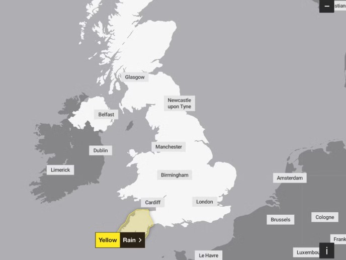
The Met Office has issued fresh yellow weather warnings, warning that already saturated ground could struggle to cope, particularly in South West England and Northern Ireland.
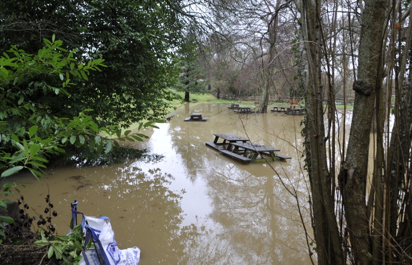
The storm, which arrived earlier this week, has already caused widespread damage, broken January rainfall records and led to the declaration of a major incident in Somerset.
Transport networks remain under pressure, and emergency services are urging the public to remain cautious.
What is happening across the UK as Storm Chandra continues?
Storm Chandra has brought a volatile mix of strong winds, persistent rain and snow in higher areas. While conditions briefly eased in some regions, forecasters say the system is far from finished.
On Friday, heavy rain will move north-east across the country, followed by showers overnight into Saturday.
The Met Office has confirmed yellow rain warnings for South West England from Friday morning until early Saturday, and for Northern Ireland throughout much of Friday.
This latest rainfall is particularly concerning because rivers are already swollen and soils remain waterlogged after days of relentless downpours.
Which areas face the highest flood risk next?
South West England is expected to bear the brunt of the next phase of Storm Chandra. Cornwall, Devon, Plymouth, Somerset and Torbay all fall within the warning area.
Rain is expected to arrive in Cornwall early on Friday before spreading north-east across the region. Forecasters expect 10 to 20 millimetres of rain in many places, with totals rising to around 30 millimetres over moorland and parts of west Cornwall.
Nearly 150 Flood Alerts in Place Across England Amid Storm Chandra Aftermath.
London, January 29, 2026 — Communities across England are grappling with widespread flooding risks following **Storm Chandra**, which unleashed heavy rain and strong winds earlier this week, breaking… pic.twitter.com/Utq30rjqtL
— JAS (@JasADRxquisites) January 29, 2026
Met Office statement: “Falling on saturated ground, this rainfall may lead to flooding and disruption. Strong winds are also likely in places.”
Local authorities warn that surface water flooding could develop quickly, increasing the likelihood of road closures and delays.
How severe could conditions become in Northern Ireland?
Northern Ireland will see heavy rain moving in overnight into Friday, with the wettest conditions expected in Antrim and Down.
Many areas could receive 10 to 25 millimetres of rain, while higher ground may see as much as 40 to 60 millimetres.
Strong south-easterly winds are forecast to accompany the rain, especially during the early hours of Friday.
Met Office warning: “There is a small chance that homes and businesses could be flooded, with some communities potentially cut off by flooded roads.”
How is Storm Chandra affecting travel and infrastructure?
Disruption is expected across road, rail, air and ferry services as conditions deteriorate. Transport operators are warning passengers to allow extra time and to check for late changes or cancellations.
Earlier this week, a lorry driver died in the New Forest after their vehicle left the road and entered a river in the aftermath of Storm Chandra, highlighting the dangers posed by severe weather and fast-rising floodwater.
Emergency planners stress that even shallow floodwater can be hazardous, particularly in rural areas where visibility is poor.
Why are coastal warnings being issued in the South West?
Alongside inland flooding, coastal communities face dangerous conditions. The Royal National Lifeboat Institution (RNLI) has urged people in Devon and Cornwall to stay well away from exposed coastlines.
Wave forecasts suggest seas could reach up to 15 feet, with the potential for waves to overtop sea fronts and harbour walls.
RNLI safety advice: “Large waves and strong winds can sweep people into the sea without warning. Conditions can change rapidly.”
What does the Met Office forecast show for the weekend?
Friday is expected to remain cloudy and breezy, with rain spreading northwards and snow falling over some northern hills.
Brief brighter spells may develop in the south before heavier rain and stronger winds return later in the day.
The unsettled weather continues through the weekend and into early next week. Showers or longer spells of rain are likely for most areas, with brisk winds and further snow over higher ground in the north.
Why does Storm Chandra matter for the UK right now?
Storm Chandra comes at a time when many catchments are already under strain. Repeated rainfall events increase the risk of flash flooding, even where rainfall totals are lower than earlier in the week.
Local councils and emergency services are urging residents to monitor flood alerts, avoid unnecessary travel during warnings and stay clear of floodwater wherever possible.