
The latest snow weather forecast Met Office update has confirmed an incoming Arctic blast that will bring freezing temperatures, icy conditions, and snowfall risk across large parts of the UK.
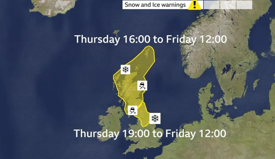
The Met Office has issued two yellow weather warnings for snow and ice, covering areas of Scotland, northern England, and parts of the Midlands, as colder air pushes south overnight.
The warnings come as the country experiences a sharp shift in conditions after weeks of wet and gloomy weather.
Forecasters say Friday will feel noticeably colder, with temperatures dropping below freezing overnight, creating the first widespread frost of February.
The sudden change matters because it increases the risk of travel disruption, accidents on untreated roads, and health concerns for vulnerable people.
What exactly has the Met Office warned about?
The Met Office has placed two separate regions under yellow warnings for snow and ice, with the greatest impact expected from Thursday night into Friday morning.
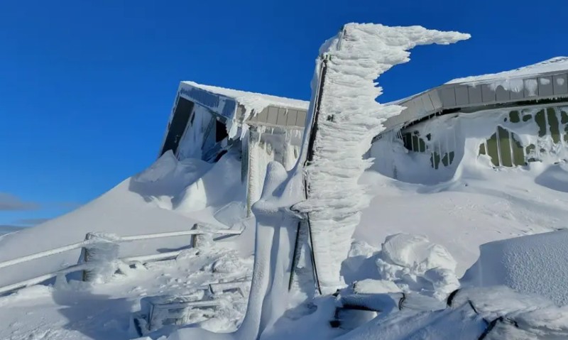
In Scotland, snowfall could bring a few centimetres even at lower levels by early Friday. Higher ground above 300 metres may see around 2cm to 5cm, while some exposed areas could receive up to 10cm.
The Met Office has also highlighted ice as a serious hazard, particularly where rainwater and melted snow refreeze overnight.
A second yellow warning has also been issued for northern England and the north Midlands. Snow is expected to fall widely, although it may not settle in many low-lying areas below 200 metres.
However, higher ground could still see 2cm to 5cm, with isolated areas above 300 metres potentially reaching around 10cm.
This warning zone includes parts of Cumbria, Derbyshire and Pennine routes, where drivers often face difficult conditions during sudden cold snaps.
When will the coldest weather hit the UK?
The worst of the overnight freeze is expected between Thursday night and Friday morning. Temperatures are forecast to drop sharply, allowing frost to form quickly across untreated surfaces.
While snow amounts may not look extreme on paper in many areas, the bigger concern is the combination of snow and ice arriving at the same time. Even light snow can become dangerous when it settles on wet roads and pavements and then freezes.
By Friday, the air will remain cold, keeping icy patches in place for longer, especially in shaded areas and rural roads.
Why is the UK suddenly turning colder after weeks of rain?
The UK’s weather has shifted because the recent “blocked” pattern that kept damp Atlantic air locked over the country is breaking down. That system brought record-breaking dull and wet conditions for many areas, alongside ongoing flood problems.
Now, colder Arctic air is moving south and replacing the mild air mass, causing temperatures to fall rapidly. This is why the UK is moving from flood-focused weather headlines to snow and ice warnings in a matter of days.
Will snow spread further across the UK this weekend?
Saturday is expected to begin cold and frosty, but also brighter for many parts of the UK. Forecasters believe it could be the driest day the country has seen for some time, with sunshine more widely available compared to recent weeks.
However, the snow risk may return quickly. Saturday night into Sunday could bring renewed snowfall potential, possibly across a wider area and even at lower levels. This means locations that avoid snow on Friday could still see wintry weather later in the weekend.
The Met Office has not yet issued additional widespread warnings for Sunday, but the developing forecast suggests the risk remains active and could change quickly.
Which areas are most likely to face travel disruption?
The greatest risk of disruption sits across higher routes, including roads crossing the Pennines and hilly parts of Scotland and northern England. These areas tend to see quicker snow build-up and longer-lasting icy conditions due to lower temperatures.
In places such as Cumbria and Derbyshire, even small accumulations can affect rural roads, minor A-roads, and routes that do not get treated as quickly as major motorways.
Commuters travelling early on Friday should also expect slippery pavements in towns and cities, as overnight freezing can turn leftover moisture into dangerous ice.
What’s happening in Aberdeen after three weeks of grey weather?
Aberdeen has seen a rare improvement in conditions after weeks of cloud cover. The city recorded a short but notable burst of sunshine on Thursday afternoon between 3pm and 4pm, ending a gloomy run that had lasted around three weeks.
While the sunshine only appeared for roughly half an hour, it symbolised the changing pattern. Forecasts suggest Friday should bring a more consistent break in cloud cover across north-east Scotland, with brighter skies expected more widely.
For residents, it has been a welcome psychological shift after what many described as a draining stretch of dull, wet weather.
Are flood warnings still active even as the snow arrives?
Yes, and this is one of the biggest concerns heading into the weekend.
Across England, 75 flood warnings remain in place, according to the Environment Agency. The agency has warned that flooding from groundwater remains likely in several southern counties, including Dorset, Wiltshire, Hampshire and West Sussex, with Kent also potentially affected.
Rivers also remain high in parts of Somerset and Wiltshire, while the River Trent continues to pose a flood risk in some areas.
This means some communities could face a dangerous mix of standing water and freezing temperatures, raising the possibility of floodwater freezing on roads and pavements overnight.
Why has the UK Health Security Agency issued a cold health alert?
The UK Health Security Agency (UKHSA) has issued a yellow cold-weather health alert covering northern England and the Midlands. The alert is in force from 06:00 on Friday until 08:00 on Monday.
UKHSA warned the cold could place a minor strain on health and social care services, with a higher chance of hospital admissions and increased pressure on GP services. The agency also warned that vulnerable people face a greater risk during freezing weather, especially those living in poorly heated homes.
Even a short cold spell can lead to an increase in breathing issues, heart-related problems, and falls on icy surfaces.
What should UK households do ahead of the cold snap?
For most people, preparation does not need to be dramatic, but it does need to be sensible. Drivers should check tyres, fuel levels and de-icers, especially if travelling over hills or leaving early in the morning. Pedestrians should take extra care on pavements that may look clear but have hidden ice.
People are also advised to check on elderly relatives or neighbours, particularly if they live alone. The combination of cold weather and rising fuel costs continues to leave many households vulnerable to heating-related hardship.