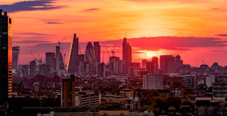
A Saharan dust cloud drifting north from North Africa is expected to reach the UK later this week, bringing the possibility of “blood rain” and unusually vivid sunsets across parts of the country.
The dust plume, currently visible over Spain in satellite imagery, is moving towards Britain on warm southerly winds and could affect skies across southern and central England and Wales from Thursday into Friday, according to the Met Office.
While the phenomenon may create striking orange and red skies at sunrise and sunset, it can also cause dusty deposits on cars, windows and outdoor surfaces if rain washes the particles out of the atmosphere.
What Is the Saharan Dust Cloud and How Did It Reach the UK?
The Saharan dust cloud is made up of extremely fine sand and mineral particles lifted from the Sahara Desert in North Africa.
Powerful winds can carry these particles several kilometres into the atmosphere, allowing them to travel thousands of miles across continents.
This week’s event developed after Storm Regina moved east into the western Mediterranean, drawing warm air northwards from the Iberian Peninsula.
These southerly winds picked up desert dust and transported it across Spain before pushing it further toward the UK.
Meteorologists say the movement of Saharan dust into Britain is not unusual. It typically occurs several times a year, most often in late winter and spring, when weather systems draw warm air northwards from North Africa and southern Europe.
Why Does Saharan Dust Create Fiery Sunsets?
The presence of dust particles high in the atmosphere changes the way sunlight travels through the air.
Sunlight contains many colours with different wavelengths. Shorter wavelengths, such as blue and violet light, scatter more easily when they hit dust particles. Longer wavelengths, such as red and orange, travel further through the dusty atmosphere.
Because of this filtering effect, the sky can appear deep gold, amber, red or burnt orange, particularly during sunrise and sunset when the sun sits low on the horizon.
Forecasters say the brightest colour displays are most likely on Thursday evening and Friday morning, especially in areas where skies remain mostly clear.
Could the UK See “Blood Rain” from the Saharan Dust Cloud?
Yes. When rain falls through air containing desert dust, the droplets collect tiny mineral particles before reaching the ground. This can leave behind reddish or brownish stains, commonly known as “blood rain.”
Despite the dramatic name, the rain itself is harmless. The effect simply occurs because rainwater carries fine desert dust with it.
The most common signs include:
- Muddy spots on cars and windscreens
- Dusty marks on windows and patios
- Light brown residue on garden furniture or pavements
The Met Office has warned that these deposits may appear if a band of rain moves through the dusty air overnight into Friday.
A Met Office spokesperson said: “The combination of warm air and Saharan dust may lead to some dusty deposits on cars or outdoor surfaces as rainfall washes the dust out of the atmosphere.”
Meteorologist Honour Criswick added that the incoming weather front may bring cloud and rain at times, although many parts of the country will still enjoy long sunny spells before the rain arrives.
Which Parts of the UK Are Most Likely to See the Dust?
Current forecasts suggest the Saharan dust cloud will be most noticeable across:
- Southern England
- Central England
- Wales
Northern areas of the UK may experience less impact depending on how the weather system develops over the next few days.
Expected Timeline
Thursday
- Warm southerly airflow carries dust into UK skies
- Conditions remain largely sunny across many regions
Thursday evening
- Best chance of dramatic sunsets due to dust scattering sunlight
Overnight Thursday into Friday
- Possible rain could wash dust out of the atmosphere, causing muddy rain deposits
Friday
- Dust remains high in the atmosphere before gradually dispersing as cooler air arrives from the west
How Often Do Saharan Dust Events Affect the UK?
Saharan dust events are a natural and recurring feature of European weather patterns.
The UK has experienced several notable episodes over the past decade. One of the most memorable occurred in March 2014, when widespread rainfall mixed with desert dust and left large parts of England coated in reddish-brown residue.
These events typically happen when three atmospheric conditions align:
- Strong southerly winds are pulling warm air from North Africa
- Dust lifted high into the atmosphere over the Sahara
- A weather system carrying the dusty air northwards into Europe
Although the skies may appear hazy during these events, the dust concentrations that reach the UK are usually low and short-lived.