
Connecticut Braces for Flash Floods as Torrential Rain Looms
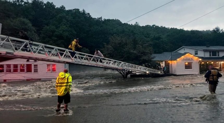
A flash flood watch is now active across the entire state as intense storms and heavy downpours roll in this afternoon. The warning, issued early Tuesday, covers not only Connecticut but also extends into Rhode Island and parts of Massachusetts, with severe weather set to hit during the peak of the evening commute.
“Showers and thunderstorms are expected late this afternoon and into the evening, dropping as much as 1 to 2 inches of rain an hour,” warned AccuWeather forecasters. That amount of rainfall in such a short time could quickly turn streets into streams, especially in more built-up areas.
To add to the concern, the National Weather Service has issued a severe thunderstorm warning for southern Hartford County, in effect until 3:15 p.m. Tuesday. “Radar indicated a severe storm with 60 mph wind gusts and quarter sized hail near Terryville and Bristol, moving east at 20 mph.” Towns under the warning include Hartford, West Hartford, Manchester, Southington, and several others across central Connecticut.
Officials are urging residents to stay alert. These storms aren’t just bringing thunder and lightning—they’re dropping serious rain in a matter of minutes.
“The strongest storms will be capable of producing torrential rainfall in a very short period of time. This could result in flash flooding, especially in urban centers,” according to AccuWeather.
And it’s not just the rain. The heat continues to smother the region. Today’s high is expected to reach a sweltering 91°F, with the heat index climbing up to 100. The ongoing heat advisory, in effect since Sunday, will continue through 8 p.m. this evening. Tonight will offer little relief, with lows only dipping to around 72°F.
Looking ahead, the midweek forecast doesn’t offer much comfort either. Wednesday will be hot and sticky again, with highs around 88°F and the risk of more afternoon showers. Thursday looks slightly cooler, around 82°F, but humidity will still linger. Showers and possible thunderstorms are expected to return.
As for the weekend? Expect more of the same—mid-80s, muggy conditions, and on-and-off rainfall.
Residents are advised to monitor local forecasts, avoid flood-prone areas, and be cautious while driving. This kind of weather can escalate quickly.
Keep an umbrella—and some patience—on hand. Connecticut’s summer storms are showing no signs of letting up.