
After a turbulent start to the month, the United Kingdom is finally shaking off the damp Atlantic influence. A dominant ridge of high pressure is currently anchored over the British Isles, promising a period of stability that will see temperatures climb well above the April average.
For Tuesday, 21 April, and Wednesday, 22 April, the narrative is one of “plenty of sunshine,” though regional nuances, from coastal breezes in the southwest to sea fret in the northeast, remain a factor for commuters and travelers alike.
Why is the UK Seeing Such Settled Weather Right Now?`
The current meteorological shift is the result of an “Omega Block” pattern beginning to form over Western Europe. This high-pressure system acts as a barrier, forcing rain-bearing low-pressure systems from the Atlantic to divert north toward Iceland or south toward Iberia.
On Tuesday morning, we saw some residual patchy cloud and scattered showers drifting westwards across the Midlands and Wales, but these have largely evaporated under the strength of the spring sun.
The air mass is currently originating from a continental source, which, while dry, brings with it a crispness that leads to sharp temperature contrasts between day and night.
🥶 A chilly start for most on Tuesday
🌬️Turning warmer in parts of the west, but a strengthening easterly breeze will keep a cool feel, especially in the east
😎 Cloud and a few showers early on, clearing westwards to bring plenty of sunshine pic.twitter.com/2ERXU2kdYc
— Met Office (@metoffice) April 20, 2026
Which Parts of the UK Will See the Best of the Sunshine?
The distribution of this “mini-spring” is not entirely uniform. Here is how the regions are faring:
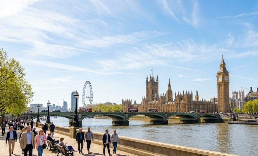
The Sun-Soaked South and Midlands
London, the Home Counties, and the Midlands are the “winners” of this system. With clear skies persisting through Tuesday afternoon, temperatures in the capital are expected to peak at 18°C, potentially hitting 19°C in sheltered urban spots.
The Breezy Southwest and the Moors
While Cornwall and Devon are enjoying sunshine, it is far from still. A tightening of isobars to the south of the high-pressure center is creating “brisk winds.” Coastal areas and high ground such as Dartmoor are experiencing gusts that make the 15°C air feel closer to 11°C.
The “Haar” Affecting the Northeast
Residents along the coast from Aberdeenshire down to North Yorkshire are experiencing a different phenomenon. Low cloud and “sea fret” (or haar in Scotland) are expected to move inland on Tuesday night.
This will linger into Wednesday morning, keeping temperatures in places like Scarborough and Tynemouth significantly lower than their inland counterparts.
What are the Experts Saying?
The Met Office has highlighted that while the days are warm, the nights remain a risk for the horticultural sector.
A spokesperson stated, “Under clear skies and light winds, we are seeing rapid radiation cooling. Rural parts of the UK, particularly in the North and Scotland, should prepare for a patchy rural frost tonight.”
Meanwhile, National Rail has issued a minor advisory for the Southwest, noting that while the weather is clear, high winds on exposed viaducts could lead to slight speed restrictions for certain freight services, though passenger lines remain largely unaffected.
The UK Environment Agency has confirmed that the risk of flooding has subsided significantly, with all major rivers now returning to normal seasonal levels following the dry start to the week.
How Does This Weather Affect Your Commute and Health?
High Pollen Count Alert
With the dry, breezy conditions, the National Pollen and Aerobiology Research Unit has triggered a “High” alert for tree pollen, specifically Birch, across southern England. Commuters who suffer from hay fever are advised to keep car windows closed and check air filtration settings.
Travel Impacts: Sea and Road
- Cross-Channel Ferries: The “brisk winds along the south coast” are creating moderate sea states. Passengers traveling from Dover to Calais may experience a more “active” crossing than usual.
- Road Visibility: While sunshine is a positive, the low angle of the spring sun during the evening rush hour on the M4 and M25 is creating significant glare. The AA has advised drivers to ensure windscreens are clean and sun visors are functional.
What Can We Expect on Wednesday?
As we move into Wednesday, 22 April, the high-pressure cell remains stationary.
- The Morning: The Northeast will start grey and damp as the overnight low cloud lingers. This is expected to burn off slowly, but some coastal fringes may stay misty throughout the afternoon.
- The Afternoon: Most of the UK will bask in “plenty of sunshine.” In the Southwest, however, we expect to see “hazy sunshine” as high-altitude cirrus clouds move in, possibly bringing the “odd afternoon shower” to the tip of Cornwall.
- Temperature Peak: Wednesday is likely to be the warmest day of the week so far, with a potential 20°C recorded in the South East.
Is a Heatwave on the Horizon?
While the current weather is exceptionally pleasant, meteorological models suggest this stability may last until the weekend. We are monitoring a plume of warmer air moving up from the south by Friday.
If this integrates with the current high pressure, the UK could see its first official “warm spell” of 2026, with temperatures consistently hitting the low 20s.