
A freak storm has battered New Zealand’s lower North Island overnight, triggering widespread travel disruption, power cuts, and at least one reported death.
The extreme weather, which struck late Sunday into Monday (16 February), produced an “extremely unusual” wind gust of 193kmph in Wellington, the country’s capital, according to local reporting.
Authorities say the storm damaged homes, blocked key roads and forced thousands of residents to prepare for further flooding.
The storm matters because it has paralysed major transport routes across the region and left large communities without electricity, while emergency services remain stretched as further heavy rain warnings stay in place.
What caused the freak storm, and how severe was it?
The storm system arrived suddenly and hit with unusual intensity, combining violent winds with heavy rainfall across large parts of the North Island.
Meteorologists described the Wellington wind gust of 193 km/h as highly unusual, with the speed strong enough to rip roofs, topple trees and damage power infrastructure.
While New Zealand experiences storms regularly, the scale of disruption from this system has raised concerns about how quickly extreme weather can overwhelm transport and emergency response networks.
Which parts of New Zealand were hit hardest?
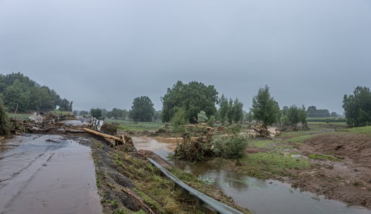
The worst impacts were reported across the lower North Island, including Wellington and surrounding districts. Falling trees damaged homes and blocked roads, while floodwater and landslides forced closures on major routes.
In Lower Hutt, local authorities reported that thousands of households were still dealing with power outages well into Monday morning.
Hutt City Council warned residents to remain cautious until around 6pm, advising people to avoid waterways and low-lying coastal areas where conditions can change quickly.
How many people lost power?
Authorities said more than 30,000 properties lost electricity across the affected region, including around 10,000 customers in Wellington. By mid-morning Monday, around 7,000 homes in Lower Hutt still remained without power.
Support for households impacted by power cuts ⚡️
Details 👇https://t.co/jiYcJHBzfC pic.twitter.com/RcdWWxSqUn
— Ben McNulty (@ponekeben) February 16, 2026
Power companies and emergency crews have been working through damaged lines and fallen trees, but progress has been slowed by dangerous conditions and blocked roads.
Why were flights cancelled and travel disrupted?
The storm triggered major travel chaos across the country’s transport network. Wellington Airport confirmed that most flights arriving and departing on the morning of 16 February were cancelled or delayed, while Air New Zealand temporarily paused operations at Wellington, Napier and Palmerston North airports.
Train services were also suspended across parts of the region, while Cook Strait ferry crossings were cancelled, leaving hundreds of passengers stranded and disrupting travel between the North and South Islands.
For many residents, the storm did not just mean inconvenience but isolation, as road closures cut off some rural communities.
Which roads were closed, and what damage was reported?
Several major routes were shut after floodwaters and debris made driving unsafe. Local reports said a mudslide trapped around 20 vehicles on Turakina Valley Road in the Rangitikei District until crews cleared the road.
Parts of State Highway 1, one of New Zealand’s most important transport routes, were also closed in sections. Photos circulating online showed collapsed road surfaces, flooded semi-rural neighbourhoods and homes surrounded by water.
What have emergency services said about the scale of the storm?
Emergency New Zealand Assistant National Commander Ken Cooper said emergency crews had faced a demanding night responding to widespread storm-related damage.
He said: “We had a very busy night, and our firefighters are continuing to respond to calls.”
Fire and Emergency New Zealand confirmed it received 852 emergency calls across the North Island overnight. Most calls were linked to fallen trees, downed powerlines and roof damage, with Wellington accounting for more than half of the total.
In western Waikato, civil defence controller Wayne Allan described the storm as short but intense, warning that even brief extreme events can leave long-lasting damage.
He said, “In terms of the number of impacted people, our primary focus has to be Pirongia’s water supply.”
Allan warned that Pirongia’s water supply relies on a single pipe, leaving the community vulnerable if further damage occurs.
Were states of emergency declared?
Yes. Authorities declared states of emergency in several districts, including Otorohanga, Waipa, Tararua, Rangitikei and Manawatu, as officials worked to coordinate evacuations, road closures and emergency shelter planning.
Emergency declarations allow councils and civil defence teams to access extra resources and respond faster to urgent risks such as landslides, flooding and water contamination.
Has anyone died because of the storm?
Local reporting said at least one man died in flood-related conditions after his vehicle became submerged on State Highway 39 on Friday, following earlier storms in the same weather pattern.
The latest storm on Sunday night came as New Zealand was already dealing with unstable weather, with authorities warning that conditions had remained dangerous in multiple regions.
What are locals saying on the ground?
Residents have described scenes of rapid flooding and dangerous winds. In Stokes Valley, Lower Hutt resident Teresa Hayes said volunteers struggled to remove water from her home as conditions worsened overnight.
She said: “We were ankle-deep at one point.”
Despite the damage, she added, “We are pretty lucky in the grand scheme of things. We are safe. That’s the main thing.”
Her comments reflect the reality facing many households, where safety has become the main priority even as communities face costly repairs and long recovery periods.
What happens next, and are there more warnings in place?
Heavy rain warnings remain active across parts of the North Island and the upper South Island. Meteorologists have warned that the storm system is tracking south, with eastern areas of the South Island expected to face severe weather next.
Warnings have been issued for the Kaikoura district, Canterbury north of Amberley, and Banks Peninsula, with forecasts suggesting between 150mm and 250mm of rain could fall by Tuesday morning.
Christchurch City Council has urged residents to prepare for persistent overnight rain and to monitor local updates as flooding risks remain high.