
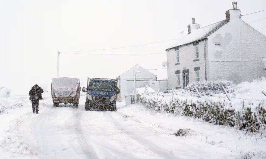
Britain could face a short but sharp snowstorm this weekend, with new snow maps suggesting widespread snowfall may sweep across parts of the UK within a 24-hour period.
Forecast charts published by WXCharts indicate snow could arrive from midnight on Saturday, 14 February, spreading from west to east across the country and continuing through Sunday, 15 February.
While many areas may only see light snowfall, some higher regions could experience heavier accumulations, with parts of Scotland forecast to receive up to 16cm.
This matters because the potential snow event comes after several days of heavy rainfall. With ground conditions already saturated, a sudden freeze could quickly create dangerous road surfaces, travel delays, and local disruption.
When will the snowstorm hit the UK?
WXCharts maps suggest snowfall could begin shortly after midnight on Saturday, 14 February, with the system gradually pushing east throughout Sunday, 15 February.
The heaviest snowfall is expected to develop during the daytime, before easing later in the evening.
Although the event is described as lasting around 24 hours, forecasters warn the exact timing could still shift depending on temperature changes and wind direction.
Which areas are most likely to see heavy snowfall?
The latest forecast indicates that most parts of the UK may see at least a small amount of snow, but higher and colder regions are expected to receive the most significant totals.
WXCharts data suggests the Cairngorms could see snowfall reaching around 16cm, making Scotland one of the most likely regions for major accumulation.
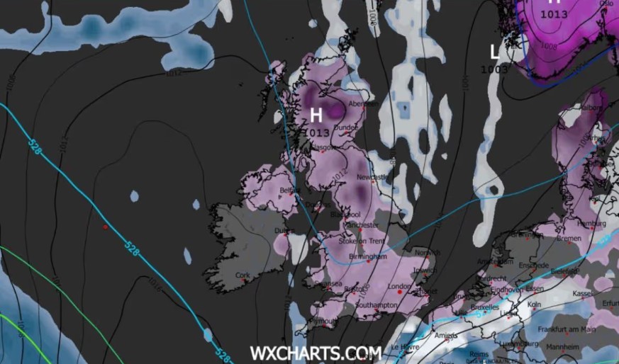
Snow is also expected to fall across parts of the Yorkshire Dales and the Peak District, where colder upland temperatures may allow snow to settle more easily than in nearby towns and cities.
In many central areas, snowfall may remain closer to 2cm, which is enough to cause slippery roads if temperatures fall below freezing.
Could some parts of Britain avoid snow completely?
Yes. The maps suggest snowfall could remain patchy in parts of the south and east, where slightly warmer air may prevent snow from settling.
Forecast “gaps” appear across parts of Buckinghamshire, Oxfordshire, East Anglia, the East Midlands, and sections of East Yorkshire.
Some coastal and milder western regions may also avoid snowfall, including parts of Cornwall, the West Midlands, and areas of western Wales.
However, weather experts often stress that these blank areas can change quickly. A slight drop in temperature could turn cold rain into sleet or snow within hours.
What does the Met Office say about snow this week?
While WXCharts maps suggest a weekend snow storm, the Met Office has taken a more cautious position, pointing to colder conditions developing later in the working week.
In its outlook for Wednesday to Friday, the Met Office said: “Staying unsettled at first with further outbreaks of rain for many. Turning colder and brighter on Friday with a chance of snow showers, particularly in the north and east.”
The Met Office also noted that Atlantic weather systems may return shortly afterwards, meaning the UK could continue to see unsettled conditions, including rain and strong winds, with colder spells still possible in northern regions.
In its longer-range forecast from Saturday 14 February to Monday 23 February, the Met Office said: “After a briefly quieter spell, associated with some colder conditions, Atlantic frontal zones look to make a return near the start of this period…
With the westerly influence, it should become somewhat milder for many, though there remains the chance that colder conditions could affect northern and northeastern parts from time to time.”
This suggests that while a snow event is possible, it may not affect the whole country evenly.
Why is this snow forecast being taken seriously?
This week’s snow threat comes at a time when much of Britain has already experienced unusually heavy rainfall.
The Met Office has confirmed that January became the wettest on record in parts of the UK, including Cornwall and County Down in Northern Ireland.
Because the ground remains waterlogged, any rapid fall in temperatures could cause widespread icing, especially overnight. Even small snowfall totals can create major problems if they fall onto wet roads and freeze quickly.
In practical terms, the danger is not only snow depth, but the conditions underneath it. Slush can refreeze into black ice, and standing floodwater can freeze in dips and rural lanes.
Are weather warnings already in place across the UK?
Yes. The Met Office has issued several yellow weather warnings this week, mainly linked to heavy rain and flood risk.
A yellow warning has been in force across parts of southern Wales and England, with reports of nearly 100 locations warned to prepare for possible flooding.
Another yellow warning has been issued for Scotland, covering areas from Perth to Aberdeen, running from 9am Tuesday until the end of Wednesday.
A Met Office spokesperson said: “Rain, heavy at times, will persist across eastern Scotland during Wednesday… This, coming on top of recent rainfall, is likely to lead to some disruption and possible flooding impacts in places.”
They added: “As freezing levels lower from the north, snow is likely to fall above 300-400 metres… where 5-10cm of snow may accumulate by the end of Wednesday.”
This means Scotland may see snow on high ground even before the weekend forecast system arrives.
Will the weekend snowstorm cause travel disruption?
There is a strong chance of disruption, particularly in areas that sit above 300 metres, where snow is more likely to settle.
Regions such as the Pennines, the Peak District, and sections of the Scottish Highlands often see faster deterioration of road conditions during sudden cold snaps.
Even where snowfall is light, drivers may face icy roads early in the morning and late at night. Rail services can also suffer delays when snow and ice affect points, overhead lines, or local access routes to stations.
The main concern is that Britain may see a “double hit”: flooding issues early in the week, followed by freezing conditions and snowfall later, increasing the risk of accidents and road closures.
How accurate are snow maps like WXCharts?
Snow maps can provide an early signal of possible weather patterns, but they do not guarantee exact snowfall totals for every postcode.
Snowfall forecasting remains difficult because it depends heavily on temperature layers in the atmosphere.
In many cases, a shift of just one or two degrees can be the difference between heavy snow and cold rain. This is why forecasters recommend checking daily Met Office updates, particularly in the 48 hours leading up to the expected snowfall window.