

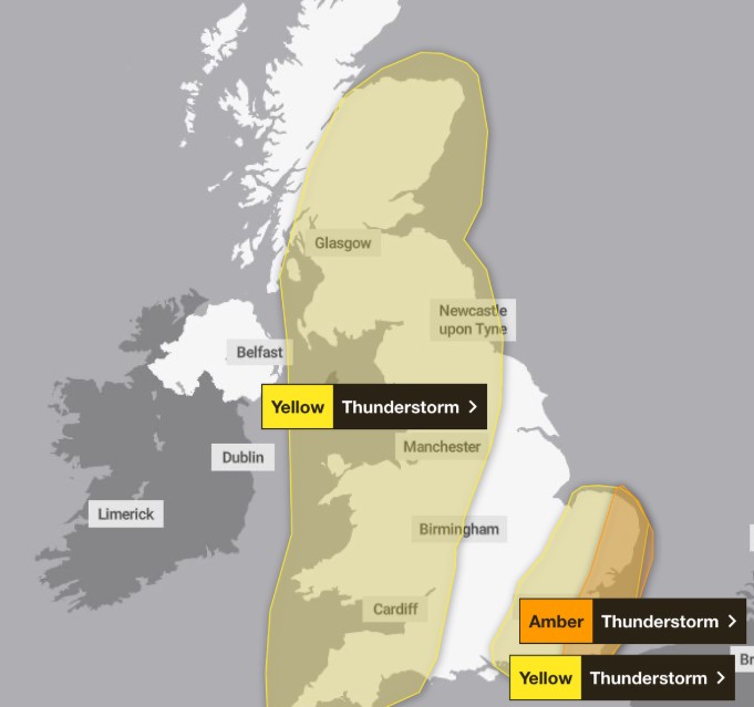
The Met Office has issued a severe amber Met Office warning for thunderstorms and flash flooding, signalling potential “danger to life” as powerful storms sweep across parts of southern and eastern England.
Tonight, regions including London, Essex, Kent, Norfolk, Suffolk, and East Sussex are bracing for torrential downpours, fierce winds, and intense lightning. The amber alert remains in force from Friday evening into the early hours of Saturday.
Forecasters have cautioned that some areas may experience 30–50mm of rain within a few hours, with gusts exceeding 40–50mph.
The combination could trigger power outages, flooding of homes and businesses, and significant transport disruption.
Road closures are likely, and the Met Office has warned that “fast-flowing or deep floodwater may cause danger to life.”
Travel Chaos and Flooding Risk
Drivers are urged to take extra care. Sudden spray, surface water, and poor visibility could make travel treacherous. Public transport services may also face cancellations or delays where routes are hit by flooding or lightning strikes.
The amber alert follows two existing yellow thunderstorm warnings covering parts of Wales, the West Midlands, and the South West, which extend northwards into Scotland and the East Midlands by Saturday.
The worst of the weather is expected to ease in the south-east around 5am, but storms will linger across much of the UK into Saturday evening.
Deputy Chief Meteorologist Tony Wisson said: “By Friday afternoon and evening, heavy and thundery showers are likely to spread across southeastern England and East Anglia, tracking north-eastwards overnight.
There is currently some uncertainty around the exact location and intensity of the thunderstorms, but there is a risk that some areas could see 30 to 50mm of rain, with a risk of even larger accumulations possible.
With much of the rain falling in a short space of time, there is a risk of impacts such as surface water flooding. Frequent lightning, gusty winds and hail could pose additional hazards.
Updates to this warning are expected as confidence increases on the exact location of the greatest risk of the heaviest downpours.”
Heat Meets the Storms
Ironically, the storms arrive after what is expected to be the warmest day of the week, with temperatures soaring to 28–30°C in parts of eastern England.
The UK Health Security Agency (UKHSA) has already issued several yellow heat health alerts across London, the East Midlands, and the South East, active until Sunday morning.
Dr Agostinho Sousa, Head of Extreme Events and Health Protection at UKHSA, warned that even moderate heat can have severe effects on vulnerable people.
“The forecasted high temperatures are expected to be short-lived but could primarily impact those over the age of 65 or those with pre-existing health conditions,” he said.
“If you have friends, family or neighbours who are more vulnerable, it is important to check in on them and ensure they are aware of the forecasts and are following the necessary advice.’’
What to Expect Tonight and Tomorrow
Friday night will bring torrential rain, flashes of lightning, and rumbling thunder sweeping northwards. The air will remain humid and warm, making for an uncomfortable night for many.
By Saturday, the heaviest downpours should ease, leaving behind scattered showers. The south-east is expected to see brighter spells, while temperatures drop slightly across the rest of the UK.
Meteorologists urge the public to stay alert and follow real-time updates from the Met Office as conditions evolve.