
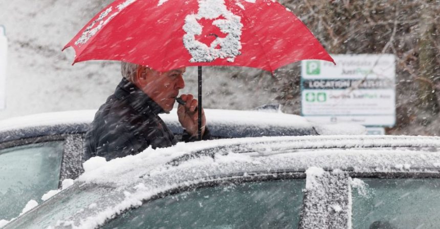
The UK is currently caught in a meteorological tug-of-war as the 2026 Easter weekend begins. While today, Friday 3 April, started with a deceptive mildness in the south, the atmosphere is rapidly shifting.
Storm Dave, a powerful low-pressure system, is currently gathering strength in the Atlantic and is on a direct collision course with the British Isles.
For the millions of Brits planning a traditional Easter getaway, the forecast has shifted from “unsettled” to “hazardous.”
The Met Office has officially named the system, triggering a wave of contingency plans from National Rail and National Highways.
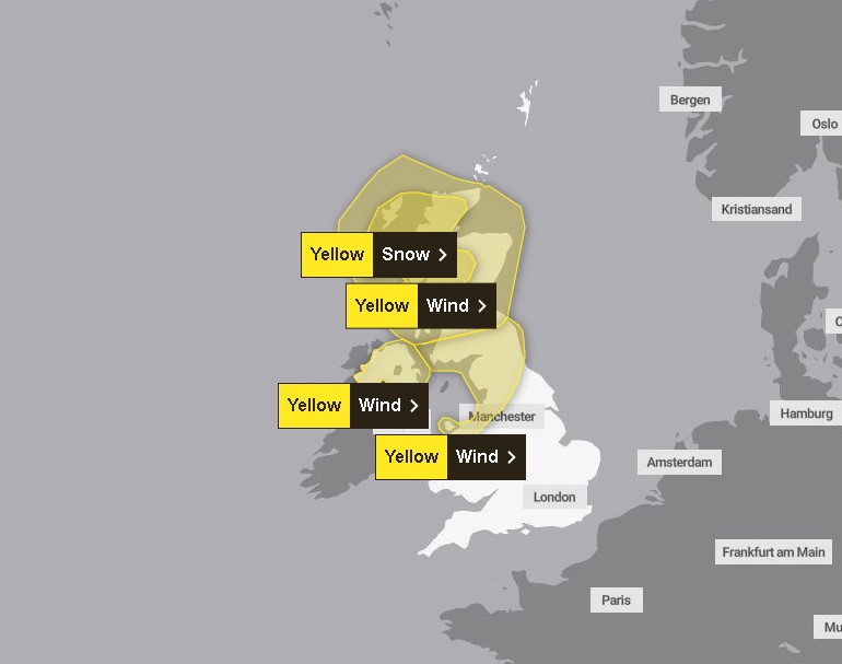
With a Yellow Weather Warning in force for Saturday, 4 April, the UK faces a weekend of two halves: a damp, breezy Friday followed by a Saturday that could see coastal gales and unseasonal blizzard conditions in the north.
When will Storm Dave hit, and what should we expect today?
Before the storm’s main force arrives, the UK is navigating a complex weather front today.
A damp start to Good Friday with outbreaks of rain ☔
Blustery showers following behind, mixed with sunny spells for Northern Ireland and Scotland 🌦️ pic.twitter.com/JSJ2x1rmoI
— Met Office (@metoffice) April 2, 2026
- The South: It remains cloudy and breezy. While rain and drizzle are slowly clearing, moisture is lingering along the English Channel. Despite the dampness, it feels relatively warm, with temperatures hovering around 14°C to 16°C.
- The North: Brighter spells are developing across Scotland and Northern Ireland, but this clarity comes with a bite. Scattered showers are turning heavy and wintry over the Highlands.
- Tonight’s Outlook: As we head into Friday night, the mercury will drop. A patchy frost is expected across Scotland, Northern Ireland, and parts of Northern England. This freeze will set the stage for the snow that Storm Dave is expected to bring to higher ground tomorrow.
Which UK regions are in the “Danger Zone” this Saturday?
Storm Dave is not a uniform threat; its impact will be felt most acutely in the north and west. Saturday morning will see the storm center move across Northern Ireland and Western Scotland.
#StormDave has been named and is forecast to bring damaging winds across northern parts of the UK, with some disruptive snow possible in northwest Scotland later on Saturday and into Easter Day #WeatherAware pic.twitter.com/J0NZYD2SPC
— Met Office (@metoffice) April 2, 2026
With a number of weather warnings issued, be sure to stay updated and check the latest info 👉 https://t.co/QwDLMfRBfs
Stay #WeatherAware⚠️ pic.twitter.com/ZzvZx09fJK
— Met Office (@metoffice) April 2, 2026
- Northern Ireland & Western Scotland: These areas will be the “front line.” Expect thick cloud, driving rain, and wind speeds that could challenge cross-channel ferry services and bridge stability.
- The Coastlines: Coastal gales are “likely” according to the Met Office, with the Hebrides and Firth of Clyde seeing the highest gusts.
- The Midlands & South: While these areas will escape the brunt of the “weather bomb,” it will remain a “windy but mild” Saturday. The primary risk here is surface spray on motorways such as the M1 and M25, which could hamper heavy Easter Saturday traffic.
What do the experts say?
The Met Office has been joined by several UK agencies in issuing urgent advice for the next 48 hours: “Storm Dave is developing rapidly. We are seeing a ‘weather bomb’ effect where pressure drops by more than 24 millibars in 24 hours.
This creates intense wind fields that can easily topple trees and cause structural damage,” says Senior Meteorologist Dr. Helen Willetts.
- Transport for London (TfL) has warned of potential delays on overground services due to debris.
- UK Environment Agency: Has issued 15 “Flooding is Possible” alerts, particularly focusing on the River Severn and the Somerset Levels, where ground is already saturated.
- Police Scotland issued a “Travel with Caution” alert for the A9 and A82 routes, where wintry showers could create black ice beneath the arriving rain.
How will your Easter travel and public services be impacted?
The timing of Storm Dave is particularly cruel, hitting during one of the year’s busiest periods for the NHS and transport hubs.
- Rail Disruptions: Avanti West Coast and LNER have warned that speed restrictions may be implemented on Saturday to protect overhead lines from high winds.
- The “Easter Surge”: The RAC estimates that 14 million leisure journeys will be taken this weekend. Storm Dave will likely turn the M6 and M74 into slow-moving corridors as drivers battle crosswinds and heavy rain.
- Power Outages: In rural parts of Wales and Northern England, the National Grid is on standby. The “breezy” conditions today are the calm before the storm that could see branches brought down onto local power lines.
Could we see an “Easter Whiteout” in the North?
One of the more unusual aspects of Storm Dave is its ability to pull cold air from the Arctic behind its southern edge.
This means that while Londoners might be walking through a windy park in 15°C, residents in the Cairngorms and North Pennines could be facing genuine blizzard conditions.
The Saturday Yellow Warning specifically mentions “wintry showers over higher ground.” For those heading to Scottish ski resorts or hiking in the Lake District, the advice is clear: stay off the summits.
What is the long-range outlook for Easter Sunday and Monday?
The “What Happens Next” scenario offers a glimmer of hope. Storm Dave is a fast-moving system.
- Easter Sunday: The storm is expected to track north-east into the North Sea. While the morning will remain blustery, the rain should clear, leaving a fresher, sunnier afternoon for much of the UK.
- Easter Monday: Current modeling suggests a ridge of high pressure will follow, potentially making Monday the best day for outdoor activities, albeit with much cooler temperatures than earlier in the week.