
The Met Office has issued a snow weather warning covering 27 areas across England and Wales, with wintry weather expected to arrive from Wednesday evening into Thursday morning.
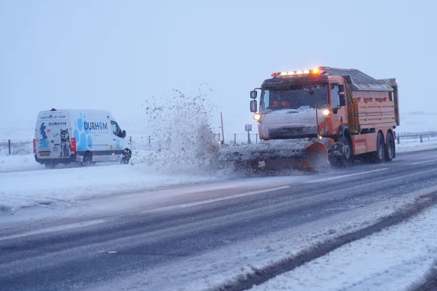
Forecasters say snowfall and strong winds could trigger travel delays, difficult driving conditions and possible power disruption, particularly in higher areas where up to 10–15cm (around 6 inches) of snow may settle.
The warning comes as a band of rain is expected to move across parts of the UK before turning into snow when colder air arrives overnight.
People travelling during the late evening or early Thursday commute have been urged to stay alert, as icy roads and drifting snow could cause sudden disruption.
Why has the Met Office issued a snow weather warning?
The Met Office issued the alert due to an expected sharp drop in temperatures as a weather system moves across central parts of the UK. Rainfall will likely turn into snow as the air cools, especially in upland regions.
The concern is not only about snowfall itself, but the wider impact that comes with it. Strong winds could worsen conditions by blowing snow across roads, reducing visibility and increasing the risk of drifting in exposed areas.
Even where snow falls lightly, wet surfaces could freeze overnight, creating black ice, which often causes accidents because drivers do not spot it in time.
This type of weather event tends to cause the biggest problems when it hits during peak travel hours, and Thursday morning could prove especially difficult for commuters.
When will the snow arrive and how long will it last?
The snow weather warning is expected to begin on Wednesday evening, continuing through the night and into Thursday morning.
Most of the snowfall is forecast to fall overnight, when temperatures are lowest. Conditions may ease later on Thursday, but the risk will not disappear completely.
⚠️ Weather warning
A yellow weather warning has been issued by the Met Office for snow
📅 18-19/02/26 ⌚16:00 – 06:00
⚠️ Please drive cautiously and adjust to the road conditions. Stay safe! 🚘 pic.twitter.com/ugM4CDUOuy
— Traffic Wales South (@TrafficWalesS) February 17, 2026
Icy patches could remain in shaded areas and on untreated rural roads well into the day, particularly in parts of Wales and the West Midlands.
For many drivers, the most dangerous period is likely to be early Thursday, when snow may still fall, and road surfaces remain frozen.
Which 27 areas are covered by the snow weather warning?
The Met Office has listed 27 areas likely to see snowfall and disruption.
In England, the warning includes Oxfordshire, Gloucestershire, Herefordshire, Shropshire, Staffordshire, Telford and Wrekin, Warwickshire, the West Midlands Conurbation, and Worcestershire.
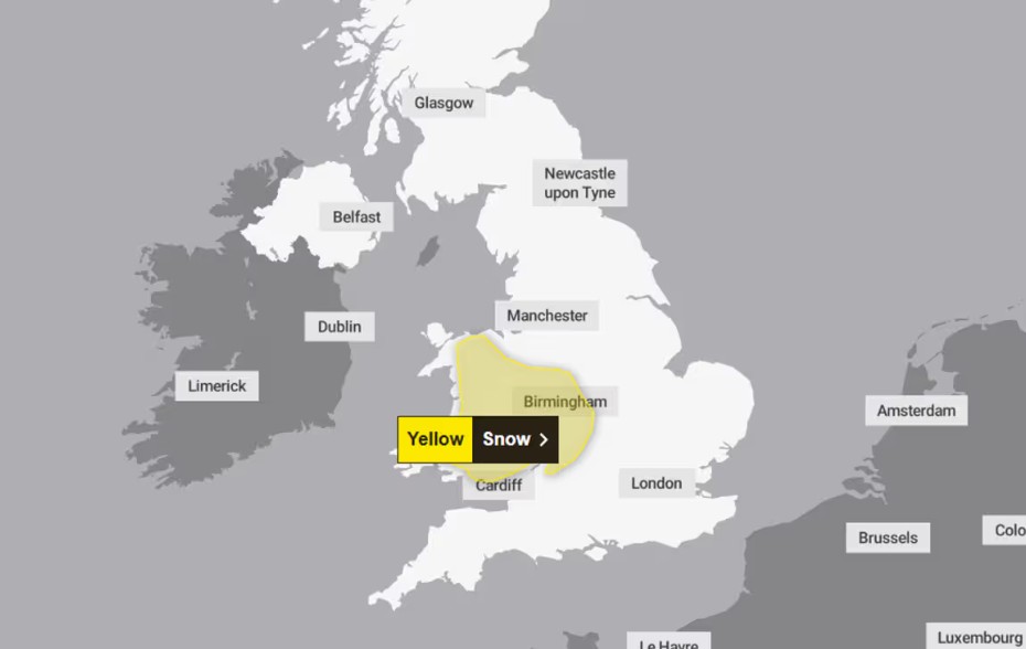
In Wales, the warning covers Blaenau Gwent, Bridgend, Caerphilly, Carmarthenshire, Ceredigion, Conwy, Denbighshire, Gwynedd, Merthyr Tydfil, Monmouthshire, Neath Port Talbot, Newport, Pembrokeshire, Powys, Rhondda Cynon Taf, Swansea, Torfaen, and Wrexham.
The spread of locations shows the warning is not limited to a single region. It stretches across much of Wales and into central England, meaning thousands of households could see travel disruption or wintry conditions.
How much snow could fall, and where is it most likely to settle?
The Met Office has warned that snowfall totals will vary depending on altitude.
Forecasters say 10–15cm of snow could build up on higher ground in parts of mid and south-east Wales, along with areas near the England-Wales border such as Herefordshire and Shropshire.
Meanwhile, snow accumulation on lower ground is expected to be much smaller, with many towns and city areas possibly seeing a light dusting or brief flurries rather than deep snow.
However, even small amounts of snowfall can create serious problems. A thin layer of snow can quickly freeze overnight, and repeated traffic can compact it into ice. This is why winter warnings often cause widespread disruption even when snow depths appear modest.
Will this snow weather warning cause travel chaos?
Travel disruption is a strong possibility, particularly for drivers using high routes and rural roads.
Snowfall on hills can quickly make roads unsafe, especially if temperatures remain below freezing. Even gritted routes can become hazardous if snow falls heavily enough to cover treated surfaces.
Public transport can also struggle, as rail services often face speed restrictions during snow and ice, while buses can be delayed or diverted if roads become blocked.
There is also the risk of drivers becoming stranded, particularly in exposed countryside routes where snow drifts can form quickly. Strong winds can worsen conditions by blowing snow back across roads that have already been cleared.
For commuters, Thursday morning could bring slower traffic, delays on major routes, and a higher risk of collisions.
Could snow lead to power cuts and service disruption?
While widespread power cuts are not guaranteed, the risk increases when snowfall combines with strong winds.
Snow can weigh down trees and branches, and gusty weather may cause debris to fall onto power lines. In more rural and upland communities, faults can take longer to reach and repair due to difficult road access.
Mobile signal disruption can also happen in bad weather, especially if local infrastructure is affected. Households in higher or more remote areas may feel the impact first if conditions worsen overnight.
What should people in affected areas do now?
People living within the warning zone should keep an eye on updated forecasts and avoid unnecessary travel during the worst period of the alert.
Drivers planning journeys on Wednesday night or early Thursday should consider leaving earlier, checking road updates, and avoiding higher routes where snow may settle more quickly.
It is also sensible to keep a fully charged phone, warm clothing and basic supplies available in case of delays.
At home, residents should ensure heating is working properly and keep torches and spare batteries accessible in case of a temporary power disruption. Vulnerable people, including older residents, may need extra support if conditions worsen.
How quickly can snow disrupt communities in Wales and the West Midlands?
Past winter events across Wales and the Midlands show how rapidly snow can affect daily life. Roads that cut through hills in Powys, Gwynedd and parts of Shropshire can become difficult to use within a few hours if snowfall intensifies overnight.
Even when main routes stay open, smaller roads often remain untreated for longer, leaving some communities temporarily cut off.
In urban areas, the disruption tends to be different. Snowfall may settle less, but ice becomes a major issue, particularly on pavements, bridges and side streets. Even a minor fall can lead to a rise in slips, traffic collisions and delayed deliveries.
This is why the Met Office warning matters even if some places only see light snow.