
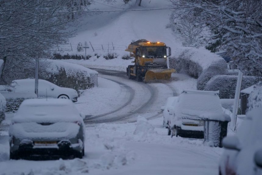
The latest Met Office snow forecast has triggered a 20-hour yellow weather warning for snow and ice across a vast 400-mile stretch of Britain, as Arctic air drives temperatures down to freezing overnight.
The warning will begin at 4pm on Thursday across Scotland and remain in force until midday on Friday, while parts of northern England will enter the alert slightly later at 7pm Thursday.
The cold snap matters because it could cause dangerous icy roads, travel disruption, and hazardous conditions for pedestrians, particularly during the busy Friday morning commute.
What has the Met Office warned the UK about?
The Met Office has issued a yellow warning for snow and ice as forecasters predict wintry conditions spreading across Scotland and northern England.
Weather models suggest temperatures will dip sharply overnight, increasing the risk of snow settling in some areas and ice forming widely on untreated roads and pavements.
⚠️ Yellow weather warnings issued ⚠️
Snow & ice across Scotland: 1600 Thursday – 1200 Friday
Snow & ice across northern England: 1900 Thursday – 1200 Friday
Latest info 👉 https://t.co/QwDLMfRBfs
Stay #WeatherAware⚠️ pic.twitter.com/jXvifrMAkF
— Met Office (@metoffice) February 11, 2026
Although yellow warnings sit at the lower end of the Met Office’s alert system, they still signal the potential for serious disruption, especially when freezing conditions arrive suddenly and affect large areas at once.
When will the snow and ice warning start and end?
The Met Office has set different start times depending on location, but the warning remains active for roughly 20 hours.
In Scotland, the warning begins at 4pm on Thursday and continues until midday on Friday. In parts of northern England, the alert starts later at 7pm Thursday, but ends at the same time on Friday.
This means the warning covers the evening travel period, overnight conditions, and the early hours of Friday morning when roads and pavements often become most dangerous.
Which areas will be most affected by the Met Office snow forecast?
The warning stretches across a major section of Britain, covering all of Scotland and reaching into northern England.
The Met Office says the worst-hit areas are expected to include the North East and North West of England, although the risk does not stop there.
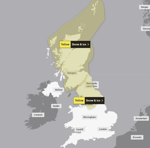
Parts of Yorkshire and the Humber, along with sections of the East Midlands and West Midlands, may also see icy conditions, particularly where temperatures fall below freezing for several hours.
Forecasters also warn that impacts could vary depending on altitude. Higher ground and rural routes often see snow settling more quickly and remain icy for longer, while towns and lower areas may experience less snow but still face widespread frost and freezing rain.
Why are temperatures dropping so sharply?
Meteorologists say the UK is currently under the influence of a strong Arctic air flow, pulling colder air southwards.
This shift is expected to drag temperatures down rapidly after dark, causing the freezing point to spread across many regions.
Even if snowfall remains light, the bigger concern is ice. Roads and pavements can freeze quickly when temperatures fall below 0°C, especially after rainfall or drizzle, creating conditions where surfaces look wet but behave like ice.
This is why sudden cold snaps often lead to accidents even without heavy snow.
How much disruption could Britain face?
The Met Office warning highlights a realistic risk of travel delays and dangerous journeys, particularly overnight into Friday morning.
Drivers may face icy stretches on motorways, A-roads and untreated country lanes, while rail services may also experience delays if snow settles or ice builds up on tracks and overhead lines.
Pedestrians are also likely to feel the effects, with icy pavements increasing the chance of slips and falls, particularly in early morning hours when frost is at its worst.
Local councils may increase gritting activity, but some roads and footpaths could remain untreated, especially in rural communities.
For many households, the warning also raises the risk of disruption to normal routines, including school runs, deliveries and work commutes.
What should people do ahead of Thursday night?
The safest approach is preparation rather than panic. People travelling through the warning zone should check local weather updates regularly and allow extra time for journeys.
Drivers should keep fuel levels up, avoid harsh braking, and reduce speed on untreated roads, where black ice can form without warning.
Residents are also advised to check on elderly neighbours or vulnerable family members, as cold weather can quickly become dangerous for people with health conditions or those struggling to heat their homes.